March 2016

Thursday March 24th, 2016

Winter Storm Warning

Greetings!

10:30am

The snow has stopped now and some wind is kicking up. I got about another 1 1/2″ while I was clearing the top driveway. The front steps were clear when I started and needed shoveling again a couple of hours later.

My little snowblower was not happy about taking foot deep snow all at once. In order to not break the belt and end up shoveling I had to take about 6″ swaths per pass. It took a couple of hours to do the top driveway, around the cars, and in front of the work shed.

As I finished up I couldn’t help thinking that the three quarts of premium that I just burned could quite possibly be the best $2 that I had ever spent.

After my lunch break I will fire up the plow truck and go after the private road. That won’t be pretty with the frost out of the ground and a lot of snow. As one guy at work phrased it yesterday, I will probably end up doing some landscaping as the plow rolls up sod and gravel.

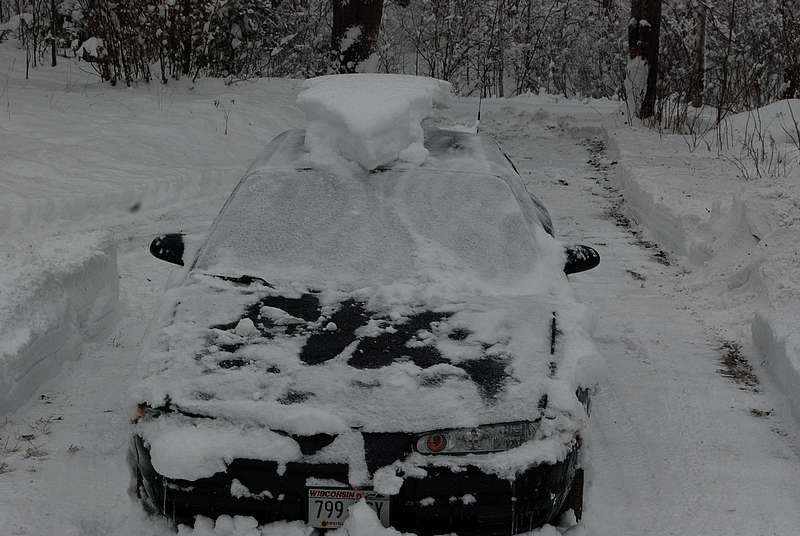
Here is a winter classic look.. the snow-hawk.

032416f

8:30am

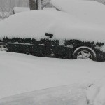
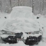
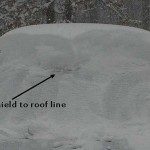
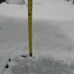
It started snowing heavily again and I was getting pretty wet so I took a break from digging out to get a few pictures. My official tally is 11-12″ but it is still snowing at a good clip. There isn’t much question that I will cross the foot mark. Click the image to get a bigger version.

Yes Sqib, a fellow could certainly find some back roads to play on with the snowmobile. I just wish that it was Feb 24 instead of March 24th!

7am

It is still snowing here. When I went out a little while ago I measured 11-12″, and the radar shows a couple of pretty good waves still heading this way.

Wednesday March 23, 2016

Winter Storm Warning

11:30pm

I went out about 10 minutes ago and found 6-7″. It isn’t snowing as hard and the flakes are a lot smaller, but we are still adding to the total. (11:45- I must have caught a lull, it is snowing heavily again, and with a little wind now.)

7:45pm

Greetings and welcome!

We are under a winter storm warning this evening. As of 7:45pm I had two inches down and it was snowing at a heavy rate. It started snowing after I got home at 5:30, so it is adding up at an inch an hour or a little more. The flakes are big, from pencil sized to not quite dime sized. When I grabbed a handful it packed, but not as much as it could have.

There are blizzard warnings for Door Co and southwest to the counties around Lake Winnebago. The wind will add to the heavy snow, with gusts over 40mph, making visibility almost zero.

There was no wind to speak of when I went outside at 7:45. the snow was falling straight down or at a little bit of an angle. At the rate that it was falling it would be difficult travel. Add in a stiff wind and it would be very difficult to see the end of the hood.

The wind is a concern with heavy snow on the trees. Having trees or branches break under the snow and wind load is a possibility. That in turn could take down power lines.

Right now the storm is ‘training’, with wave after wave of precip following west to east like train cars on a track. On the radar it looks like a river going west to east.

The last big storm pinwheeled a line of intense snow through the area from south to north and was done in a few hours. This one is just a river of moisture over one path.

The northern edge of the snow on the radar is right about at the Florence Co Line. The southern line is at about Sheboygan, and it has stayed there for a couple of hours. That tells me that the storm isn’t moving much. At that point we could see some pretty good snow totals in the areas that do get hit. We are only about 30 or 40 miles from the north boundary of the snow, but for now we are in the river.

There is a bountiful supply of moisture, enough cold air, and like all of the best spring snow storms, a secondary area of low pressure with more moisture and more energy to reinforce the storm. The storm is expected to continue into mid-day tomorrow.

If we stay in the heavy snow all night it will bring 10″ plus totals, and still coming hot n heavy after sunrise. If the storm moves south 50 miles we might get off the hook at 3-4″, but that isn’t looking good at the moment.

At 8:30pm I just measured 3 1/2″. By my estimation it was falling at close to 2″ an hour while I did my update.

I will update again with totals in the wee hours and/or in the morning.

Have a good night and thank you for visiting!

RJB


Monday March 21, 2016

Greetings!

A stretch of warm weather and low snow totals ended our snowmobiling season early. ElNino winters are usually bad for snowmobilers, and this one lived up to the hype.

We had a few warm weeks, and a coupe of really nice days, the warmest being 67. Mud season soon followed, with foot deep ruts and people parking cars out by the road.

The ground is bare, and the frost is out of the ground now in most open areas. Sheltered areas might still be a little soft, and places with more snow a little north are probably behind in the ground thaw.

Once the snowmobile trails closed so did the ATV trails. They stay closed until the ground firms up. Usually they reopen the first week of May, but it can be early or late depending on conditions.

The Peshtigo River ice opened early, and last Saturday found high water (~30″) for those that made it for opening weekend at Kosir’s Rafting. It is at +18″ now and falling, but we have a big storm possible mid-week that could send it right back up.

Did I mention that there could be a big storm this week? We could see a little rain or snow ahead of the main event coming for Wednesday into Thursday.

Depending on where the storm tracks, somewhere could see 6-10+ inches, along with a good bit of wind. With the amount of cold air shown it could be fairly light snow and subject to a lot of blowing and drifting.

Right now where will it hit is the question. There have been two scenarios being shown. One has from Green Bay south getting the big stuff. Scenario two moves it 100 miles north for a perfect bulls eye on the area from Green Bay to Iron Mountain. The latter is what my newest guidance is showing, with the GFS and North American models in good agreement.

As shown it will be a good storm somewhere.

There are a couple of more big storms showing up in the 16 day GFS.

There is a lot more to talk about but it is time to go for tonight. Have a good week and thank you for visiting!

RJB


March 17th, 2016

Greetings and welcome!

Whitewater rafting starts early this year. The river opened up last weekend and is running high, so Kosir’s is opening the for the season early.

The river is heading for the 24″ mark, and we got about 1.5″ of rain yesterday. If you want to catch the big spring water, here is your chance. Call Kosir’s at 715-757-3431.

Updates will resume here in a day or two.

RJB