July 2017

Wednesday 7-26-17

230pm

Greetings and welcome!

The rain today has so far been unimpressive. They had some thunderstorms to the south of here, but the best that I have seen is a couples of brief showers pounding on the roof. It looks like the front is moving south of here so we are probably going to end the day, and the week,  with less than 1/2″ of rain.

For once the weekend forecast is pretty obvious. Sunny, low 80s, lows around 60. (Can we believe it?)

Events..

Crooked Lake ATV Club Burger & Brat Fry & Craft sale- At the Crooked Lake Sportsman’s Club Sat July 29. Bucket raffles, Booze & meat raffles.

Wienerfest North- Sat July 29 Lakewood- Meatski’s wieners, military equipment & representatives, presentation of colors @ noon, meat raffle, Hot dog costume contest, Happy Schnapps Combo 4-pm.

8th Annual Ride for Rescue- Benefits Crivitz Rescue Squad- Leaves @ 11:30am Contact Dan & Tim’s Riverside in Crivitz.

Twin Bridge Ski Team Learn To Water Ski Day- Sunday At Stephenson Town Park by Boat Landing #3 on High Falls Flowage. Information: 715-927-3363

Brazeau Fire, Ambulance and Dive Annual Picnic- Saturday July 29 Link

The Last Bear Point Yacht Club float down the Menominee River Trip of July- Armstrong Creek Polish Heritage Days- Fri, Sat, Sun-

Whitewater Rafting- We are still seeing above normal water levels, so rafting this weekend should be very fun. Get it while you can!

Have a good weekend and thank you for visiting!

RJB

Friday 7-21-17

Greetings and welcome!

It was not the week for weather that I was expecting. We had a rowdy storm Tuesday afternoon that brought some gusty winds and rain so hard I could only see about 100 yards. It was all over in about 20 minutes. I saw two trees down from the storm, but they were ready to come down anyway. We didn’t lose power, but Crivitz did.

The battleground where all of the big storms were stayed downstate this week, and some of those areas got disastrous flooding again. We ended up with a hot humid week that stayed in the 80s.

The weekend forecast is a strange one. The NWS has us at a 70% chance of rain/storms tonight, 40% Saturday and Sunday, and 30% Saturday night. The TV says a chance tonight, and a minor chance Saturday night, and a better chance Sunday night. My guidance suggests that tonight and Saturday night would be our best chance. Temps from the NWS are 77 Saturday and 74 Sunday. I will inject that Saturday will be humid.

As jumbled as the forecast is, I don’t see anything that would merit adjusting plans. As always be ready for a passing shower or storm.

The whitewater rafting will again be outstanding this weekend. The Peshtigo River is at about a +8, yet another record for today since they started keeping records in 1998. Normally we would be around 200CFS, pretty close to un-runnable. Today we are at 552. I consider anything over 300cfs the fun zone. Get it while you can!

This weekend is hog wrestling weekend at the Caldron Falls Bar. They have new owners so there will be some minor changes like different T-shirts and vendors, and many new food offerings from the new owner’s barbeque catering service. There will be karaoke tonight, and there will be live music in the daytime tomorrow too. Beyond that it is business as usual with the hog wrestling, band at night and fireworks to close the event. They also have a fancy new web site.

This weekend is also popular with the OWI task force and a wide variety of law enforcement looking for people getting out of line. Use a taxi, shuttle, or a safe ride home if you are going to indulge.

I promised some cool pictures, here we go. I paid a price for some of these, which reminds me, bring REPEL.

As usual the clock is not my friend so I have to run along. Have a fun weekend and thank you for visiting!

RJB

Tuesday July 18th, 2017

Greetings and welcome!

I don’t know much today and the to do list is about eight feet long so it will be a short update for now.

First up, the TV weather guy said that today is the day with the highest normal high of the year. In Green Bay that would be a normal high of 80.

We are on the way to a humid 85 degree day that is expected to end with some strong thunderstorms. We have a hazardous weather outlook going and a 2 of 5 on the severe weather index.

This week’s weather is a big question mark. The way that the guy on TV laid it out is that we have a quasi-stationary front setting up camp over the lower 1/3 of WI that is dividing hot & humid air to the south and cooler air to the north. As it moves north and south the areas near the battleground will likely see storms.

That is a nearly impossible scenario to predict, so I am not going to spend much time on it. I will call it a hot week in the mid-80s with a chance of storms just about daily, usually in the afternoon.

Now if I can’t tell you what Thursday holds, the weekend is obviously a guess. Right now my guess is for highs in the low 80s and a chance of a storm late Saturday and a better chance Sunday.

I have some cool pix to share, and I will catch up on events for the weekend. Right now I am running to get some of my list done. I have 2 web sites on high priority status, and one that will hit the net today, and I need to fix the brakes on my car before it gets too hot outside. I need a clone.

I will be back soon.

RJB


Thursday July 13th, 2017

Greetings and welcome!

The rains came again last night. Like the Tuesday night rain the waves of the storm lined up on a rail and hit the same spots with wave after wave of thunderstorms and downpours. The bad news is that it hit the exact same spots as the Tuesday night storms. There are areas between here and Lakewood that got 3″ or more of rain two nights in a row.

I have a friend on the other side of Thunder Mountain that was on the east end of it. His driveway and yard are seriously wrecked from all of the runoff erosion. My driveway took it hard Tuesday night, but I haven’t seen the damage from last night yet.

The storm last night also caused a few power outages, including here. It went out about sunset, and came back on about midnight.

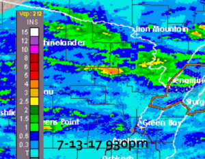
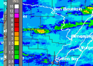
I know you guys saw the radar returns from Tuesday evening, now I am going to put Tue & Wed side by side to show how the same areas got hit. If you look right under the top stair step of Marinette Co you can see last night’s rain was 3+ inches and so was Tuesday night’s. Ouch.

The USGS river gauge by Kosir’s measured about 2.5″ of rainfall for the week, with all but 1/2″ coming in the past two days. I am going to say that it is understated a little. I would bet that private rain gauges show double that.

The river itself was not very affected by the Tuesday night rain, that was all south of the area that matters to the river. Last night’s rain also blessed the upper and lower watersheds. The river shot up from about 700CFS to 950 in under 12 hours, a rise of about 6″. That is a pretty fast spike, bearing witness to the intensity of the rainfall.

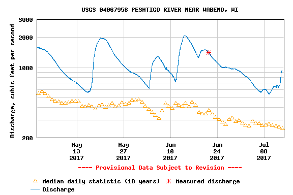
Whitewater rafting will again be outstanding this weekend. Right now the river is at about a +14″ by my guess. That is just incredible. Normally we would be at about a zero or maybe -2″. As far as CFS the median flow for today is 247cfs, right now it is at 940cfs. Incredible.

I ran a graph on the USGS gauge from May 1st to today. The river has not gone low enough to hit its mean flow since May 1st, but it did go above flood stage twice. By my reading of the graph, its lowest flow was about a +5″. That is something that I have never seen in my 25+ years of paying attention to it. Unbelievable. The mean flow is the little yellow triangles, the actual flow is in blue.

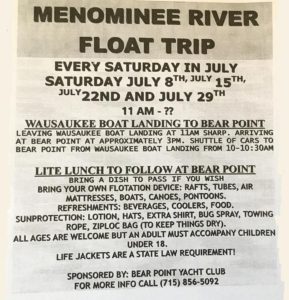
One previously discussed item is the float trips with Bear Point Yacht Club on the Menominee River. I mentioned it in an update a while ago, and I want to remind you that they run them every Saturday in July.

The weekend weather looks about as nice as it gets. Behind our rain are a couple of big areas of Canadian high pressure. Usually high pressure means nice days. In this case it will, but.. between the two areas of high pressure there will be a minor chance of a shower or storm. Right now the timing on this looks like it will be about sunset Saturday, but the NWS has a 30% chance after 1pm Saturday. The TV just said that there is a slight risk for severe weather for Saturday/Saturday night.

Well I have a million things to do so I am going to run along. Have a good weekend and thank you for visiting!

RJB