Greetings and hoppy Easter!
This is one of my all time favorite Easter cartoons. It is just silly.
It is also April 1st, aka April Fools Day. I didn’t do any April Fools pranks this year so you guys are safe for now.
I spent the day with my head in the computer working on another web site. When I finally looked around about dinner time I checked the forecast. I wish that was an April Fools prank, but I doubt it.
We are under a winter storm watch for tomorrow night and Tuesday with a general 6-10″ of snow expected, and higher amounts some places, like here. The TV weather channel alerted me to this when I saw their storm watch covering our region. Watching their predictor animation we could see over 11″ by Tuesday night.
Where the heck was this when the snowmobile trails were open and we had such a nice base?
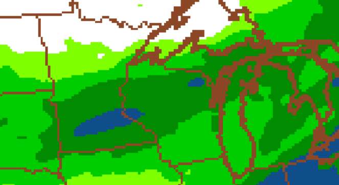
Here is a total precipitation estimate from the North American model. The green is 0.6-1.0″ of RFE, and the blue is 1.0-2.0″. RFE is short for rainfall equivalent.
Usually I estimate snowfall using a 10-12″ of snow to 1″ of rain multiplier. If it is really wet and heavy snow it could go 6 or 8 inches per inch of water. The really puffy snow can go as high as 20+” of snow per inch of rainfall. For now let’s stick to a 10 or 12 of snow per inch of water ratio.
Virtually all of my guidance show us in for at least 6″ of snow, and likely more. In the winter when we are snowmobiling I would be very skeptical of such a perfect snow forecast. There is an old saying.. The probability of an outcome is the inverse of its desirability. At this time of year the snow is just a nuisance, so I believe this forecast.
Here is what I found among the various sources..
TV- Snow from 6pm Monday to midnight Wed morning- 6-10″, 11+” in Lakewood
NWS- 3″ Monday night, 6″ Tuesday, ? Tuesday night,
NAM Model- Similar timing, 6-12, possibly 12+
GFS model- Similar timing, 6-12″
ECMWF- (European model)- Similar numbers, similar timing
Usually when the models agree that closely 24 hours out it is a likely outcome.
We had a cold night last night (+5ºF) and while it was sunny today I don’t think that it got much above 30. The sun was out enough to clear plowed roads bare but it only knocked our 7-9″ down to about 5-6″. It won’t be sunny or warm tomorrow, so most of that should still be there when the next snow comes.
Part two of this is that the snow won’t be going anywhere for a while. Low temperatures for the next week are in the 9-15 degree range, with the warmest day next Sunday at +38. The sun will knock the snow down a little, but with highs around 30 and a lows of 12 or 15 there won’t be a lot of fast melting other than on the roads. Our average high & low temps for today are 45 and 28F.
That snow and cold will put me in a very busy place tomorrow after work. I did a just good enough plow and snowblowing job yesterday, assuming the the April sun would clean the rest up pretty fast. Now I need to push back snow piles in the driveway to make room for the new stuff, and dig out some firewood before it is under 16+ inches of snow. Not happy.
So will they re-open the snowmobile trails? I doubt it, but I guess that they could if we ended up with 12-15+ inches on the ground. I have seen them open as late as April 15th weekend. For now people lucky enough to have off-trail spots to ride are already in the green north of about Benson Lake Rd just with the snow from yesterday.
It is getting late so I am going to get this posted and go hope that this storm goes around us like so many did during the snowmobiling season.
Have a good night and thank you for visiting!
RJB