2019

Saturday Night 7-20-19 Storm Damage Update

Greetings and welcome!

I did some travelling today and got an eye full of storm damage. Here is the Cliff’s Notes version..

Lakewood and Mountain are out of power and probably will be for a while. There was a lot of tree damage from Lakewood south to Mountain and west on 64, including trees on power lines. Both 32 and 64 west of 32 were definitely shut down last night with blown down trees across them. They got hit pretty hard down there and it will not be an easy cleanup. The highways are open, but there are still trees right on the road’s edge.

Route-

C&F in Silver Cliff to Lakewood on F, north to Carter on 32, south to Mountain BP gas station on 32, back to 64 west, west on 64 to Hwy T (Animal’s Bear Trail), 32 & F back to Silver Cliff.

Discussion-

This was supposed to be a grocery and cig run. The damage wasn’t to bad around here (none) so I didn’t expect what I found.

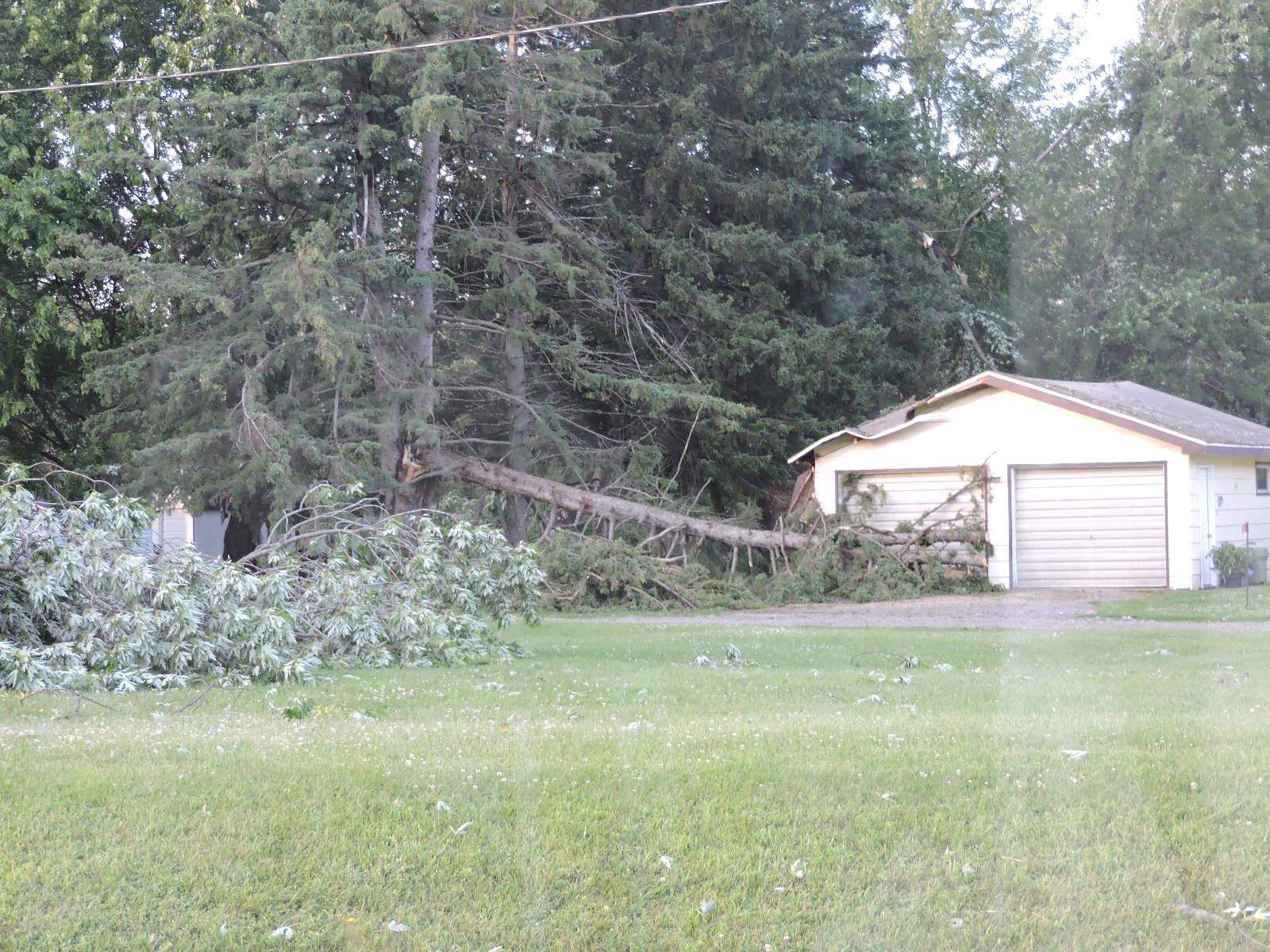
Hwy F to Prospect Lodge had only an occasional small branch down. Nothing to see here. At Prospect Lodge there was a tree down on a house and a pretty big one had fallen across the road and been removed enough to let traffic pass. There was an occasional tree down between there and the Lakewood golf course.

The golf course had a couple of trees and a sign down. A house across from the church & fire department just east of 32 on F had a bad night with trees down & a tarp on the roof. Power was out in Lakewood and all of the stores and gas stations were closed.

Going north to Townsend there was an occasional big tree down. Townsend had more big trees down, but they were scattered. The sumac bushes had leaves turned over like they had been thrashed pretty good. The power was on in Townsend.

There was an occasional tree down going north to Carter. The smoke shop was open but they had no fuel, I am guessing that they were on the casino’s generator power.

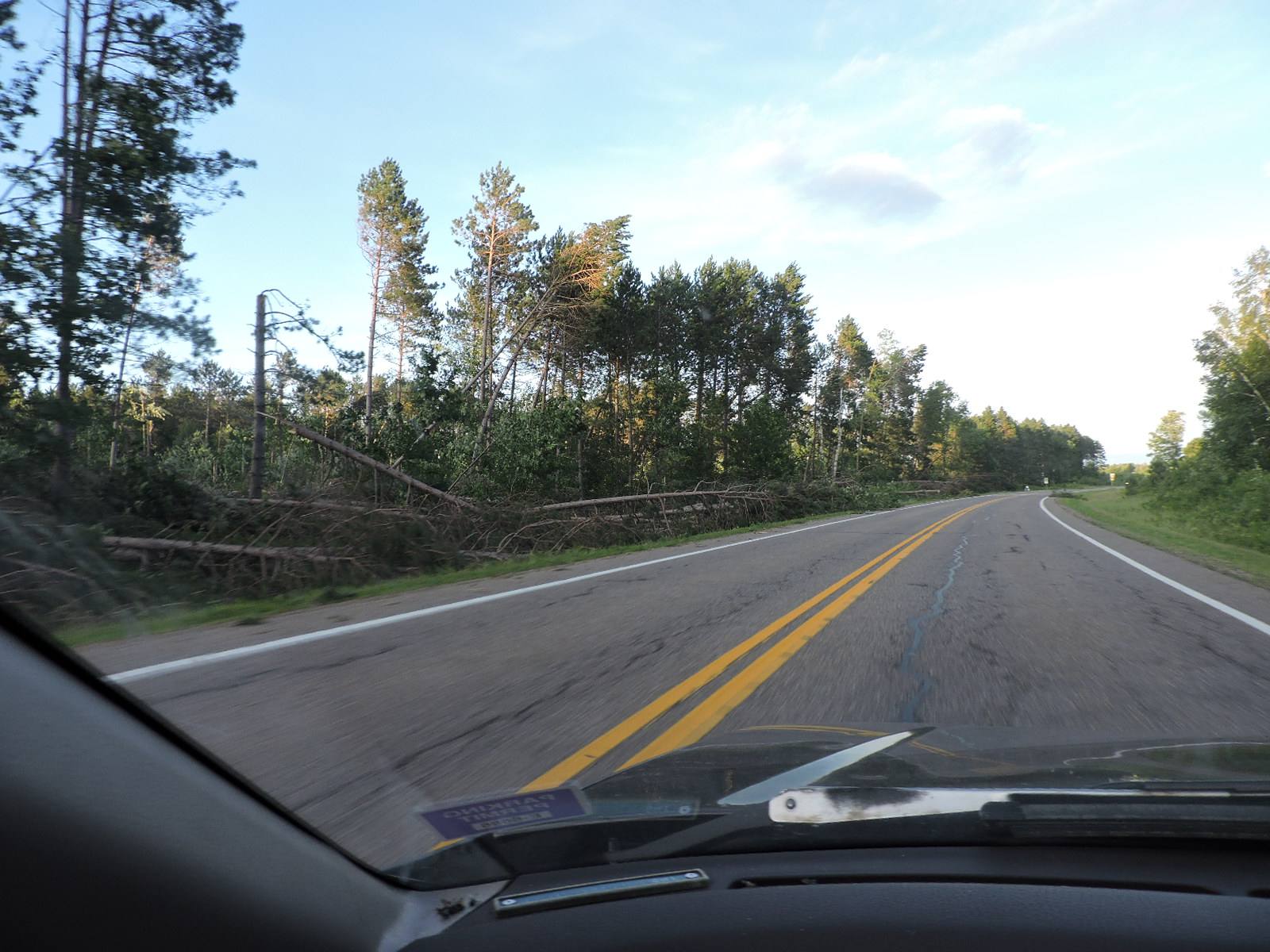
From Lakewood south things got really ugly. There were a lot of trees down between Lakewood and Mulligan’s, and again about a mile south. Some were on a power line. The ones south of Mulligan’s probably would have made the road impassable last night.

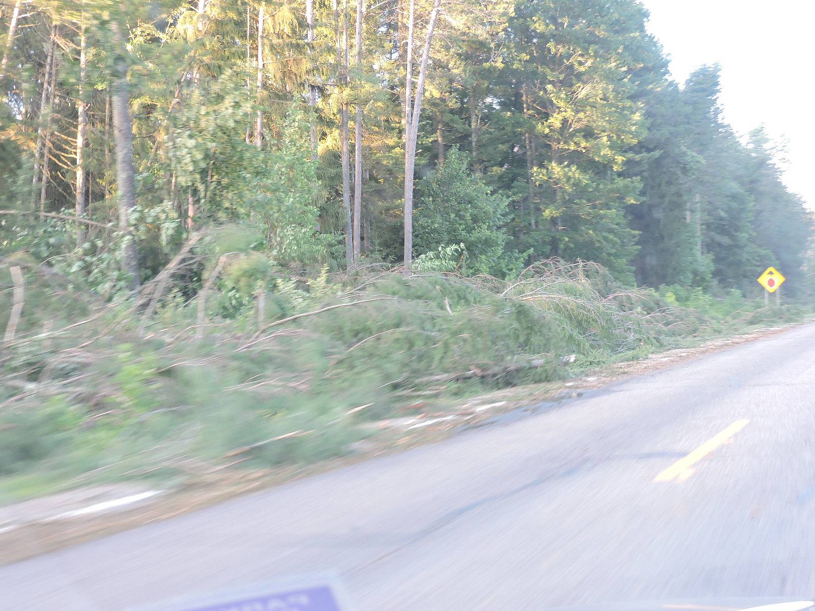
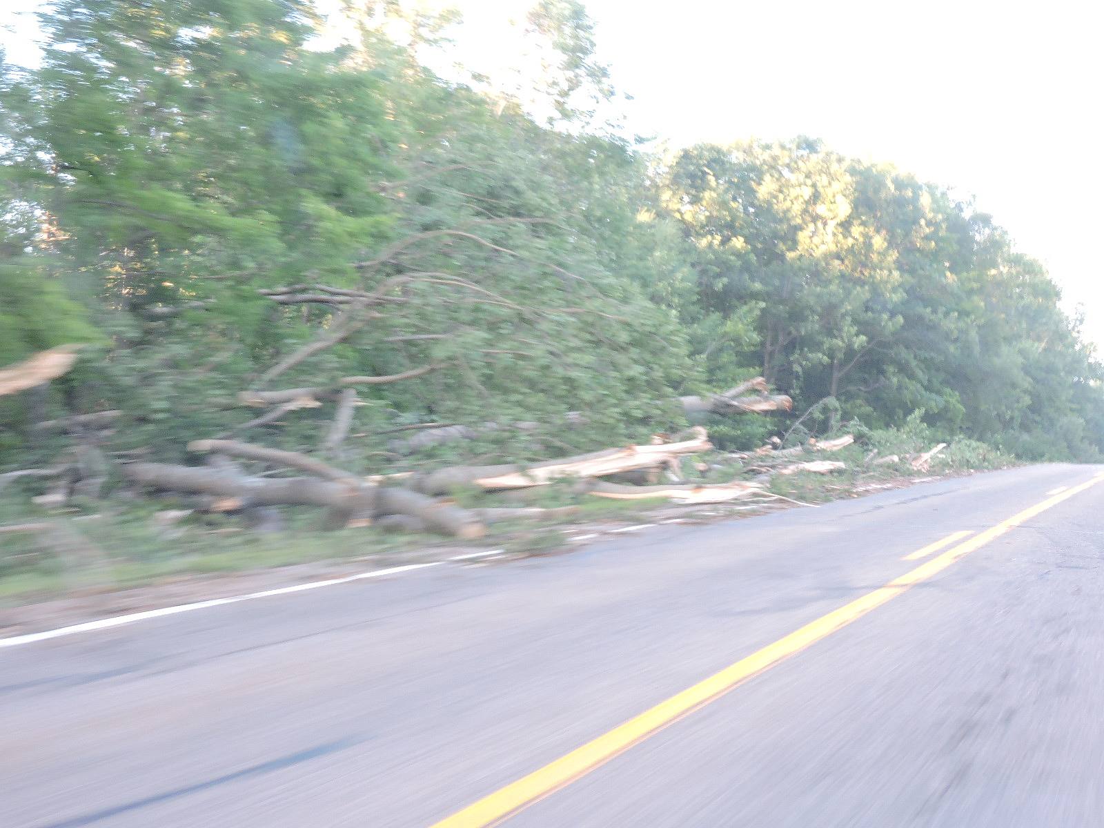
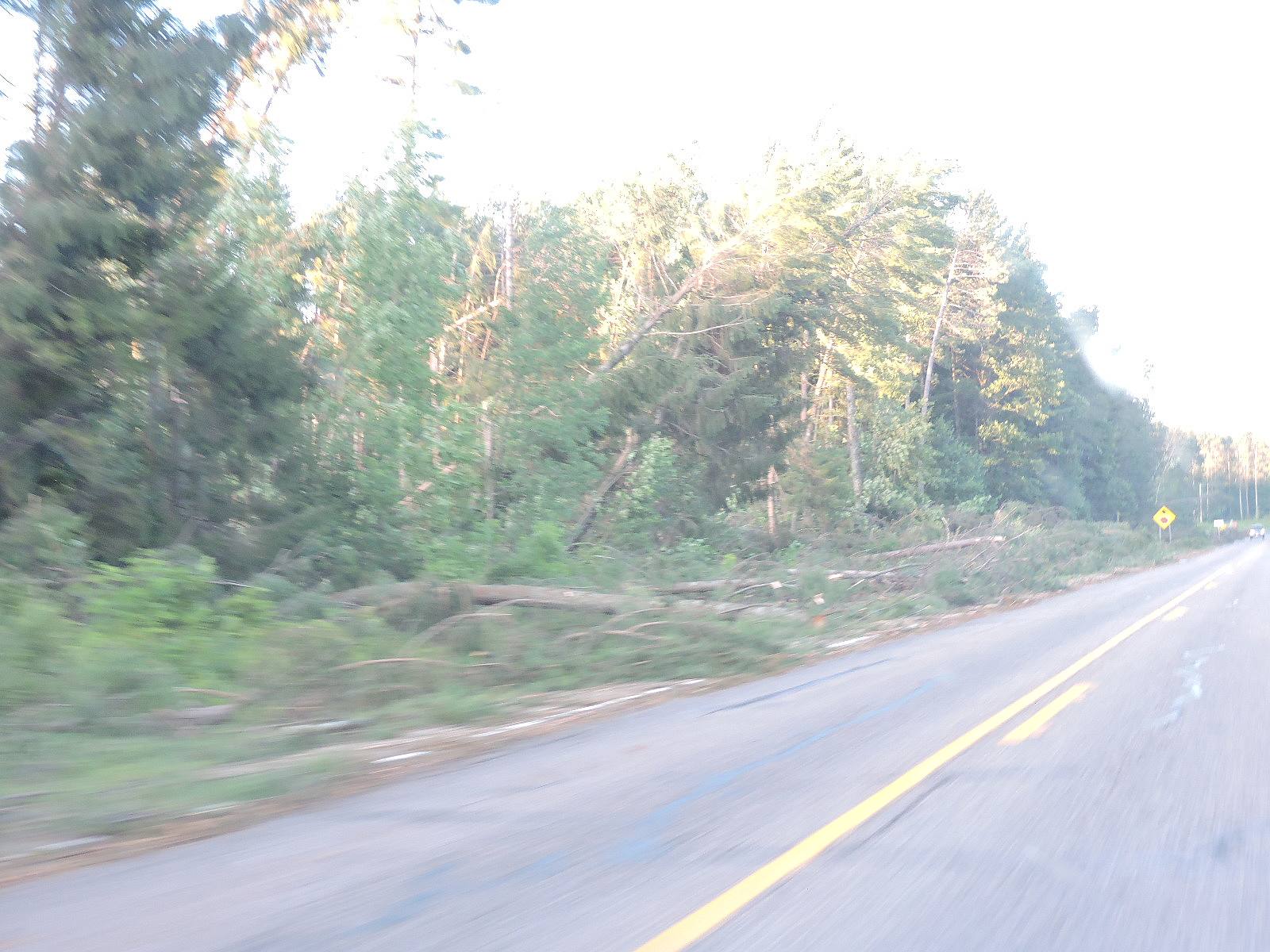
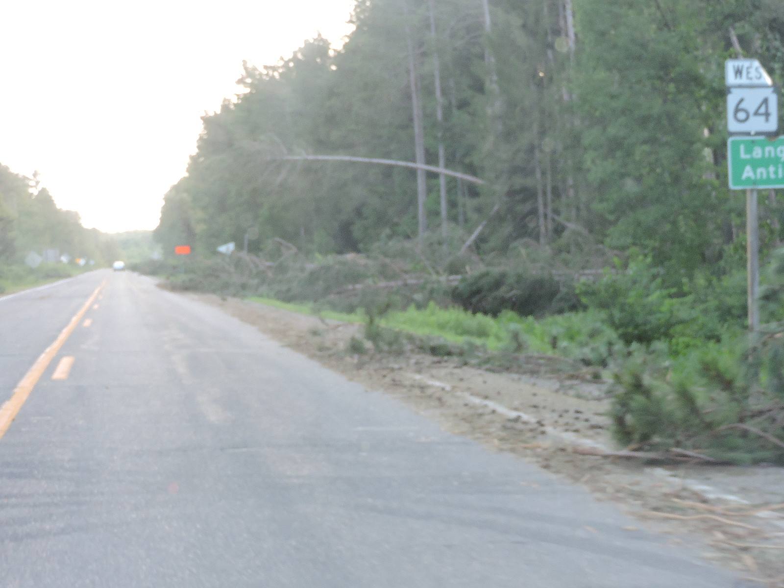
From Riverview VFD south to Mountain BP gas station they took it hard. There were a lot of trees down, and even a little wind damage to the gas station. Going west on 64 there were trees down across the road for at least the first half mile. Unless you were on a D-8 bulldozer that would have been impassible last night. There were a LOT of trees down. The damage was hit and miss from there west to Hwy T, but there was really a lot of it.

The power was out from Lakewood to Mountain. The Bear Trail was open but I didn’t know if they were using line power or a generator.

The bottom line is that there was damage from about Carter south to Mountain and points west. Lakewood and south they took it hard.

To me this looked like straight line wind damage. How do I know? The debris was all in the same direction. With a tornado the debris get scattered more randomly. Most of this damage was from the north with trees falling south or from the west and trees falling east. I didn’t have my drone so I couldn’t look at it from the air, but that is my assessment from the car.

That is little consolation to the guy who’s yard looks like a bomb went off, but straight line winds can be as strong as an EF0 or EF1 tornado. The EF0 starts at 65mph, and I would put a fat bet down that the areas that I saw today saw all of that. An EF1 starts at 86mph. I’d have to see radar forensics to really know how high that they gusted. The TV showed 65-70mph+ gusts last night.

Traffic was moderate and between that and the 7pm sun it was hard to get pictures. The camera apparently doesn’t do well at 55mph either. Whatever. Here are some pix.

RJB


Saturday 7-20-19

12 Noon

Greetings and welcome!

The morning news out of Green Bay did not cover our area much for storm damage. From what I saw on FaceBook-

-Hwy 32 north of 64 was blocked for a while.

-Mountain and Chute Pond had a lot of trees down and wind damage, power outages.

-Bear Paw scout camp had a ton of trees down

-Pelican Lake took a lot of wind damage

– A bluegrass festival NW of Antigo took a lot of damage.

-A friend near Parkway & W had a few big trees down.

-There were trees down reported to the NWS near Crivitz and a little SE of Wausaukee. I have not seen/heard reports from there yet.

We aren’t done!

Looking at the radar there are two big masses of red and orange heading this way.  Hopefully last night’s storms took enough energy out of the atmosphere that these won’t go severe. I guess not. There are tornado warnings between Green Bay and Oshkosh and points west. The severe area reaches north almost to Hwy 64.

There are two different lines of storms heading this way. One is almost on us, one is back by the MN/WI border. It looks like a wet and stormy Saturday, but so far it does not look like it will go severe north of Hwy 64. That could change so keep an eye on the sky and watch/listen for warnings.

In my opinion it seemed like the storms here faded out just a little too easily here last night, mostly because they came at sunset with less heating from the sun. (My apologies to our friends that did take damage). At that point the atmosphere did not fully purge, and there would be storms again today.

When we are at a 4,000 CAPE there is going to be a lot of energy and moisture for the atmosphere to purge. I saw where someone called yesterday a ‘particularly dangerous situation’. Yes indeed it was. I fully expected multiple tornadoes and possibly some really bad ones EF3 or bigger.

I will grossly oversimplify again here.

When I say that the CAPE is 4,000 j/kg, that means that a parcel of air on the ground has 4,000 joules of lift trying to make it rise. A typical Kg of air is about 27 cubic feet, and smaller when it is super humid and it weighs more. That would be a 3’x3’x3′ cube of air. At 4,000 j/kg there would be 2,950 foot-pounds of force trying to lift that 2.2 pound parcel of air. A ton and a half of force trying to lift 2..2 pounds of air? That is just an insane amount of force, and that air will rise violently. Now multiply that across a large area of northern WI and there is a really remarkable amount of energy involved. I don’t know how many “Hiroshima bombs” that would translate to, but it might be an apt way to quantify that amount of energy.

Unrelated-

I saw on Facebook where the county banned boats from the Twin Bridge Park beach for a month after someone kept stealing the swim area buoys. (Link)

Have a good Saturday and thank you for visiting!

RJB

Friday 7-19-19

10:30pm

The storm has passed with no damage at all here. It was a tremendous light show with plenty of rumbling and a little heavy rain. The wind blew a little but did not get big.

At one point I was dressed with the car door unlocked ready to flee to a basement. There were some impressive cloud formations coming my way and the radar looked grim. There was almost the beginnings of a tornado* between here and Lakewood but nothing came of it. (*Inbound & outbound winds on the radar converging)

The TV radar showed some high winds from about Lakewood down to Mountain west of 32 and over toward Hwy 55. The radar clocked winds over 60. The NWS reported trees down in Mountain and Crivitz.

One other thought.. it seemed like a lot of the lightning was cloud to cloud. There were not a lot of ground strikes here.

There may be damage in other areas. I don’t know. Hopefully we got off easy because the storm came through at sunset without the sun causing additional convection.

There were a lot of power outages around Rhinelander, Merril and Antigo earlier in the storm. I suspect that they had wind damage in those areas.

RJB


..it’s a hot one.. like 7 inches from the mid-day sun…

Greetings and welcome!

At 4:.30pm Athelstane Weather is showing us at 91.6F off of a high of 95.5. The dew point is at 76, downright tropical for humidity levels.  It starts getting uncomfortable at about a 60 degree dew point and we have 72. Between the heat and humidity it is brutal outside.

With that moist of an atmosphere holding that much heat something real bad is bound to happen. Severe weather somewhere is almost guaranteed. I looked up the CAPE values and shear and became very concerned. This is not good at all. On a 1-6 scale of severe weather potential we are at a 4 or 5.

CAPE values- In a gross oversimplification CAPE is a measurement of how buoyant the air by the surface is. That hot air wants to rise and the cold air above it wants to fall. That hot air rising violently can cause thunderstorms, and the more violently that it wants to rise the more likely that the storms will become severe.

I hated physics in tech school. Once I became a weather watcher that changed a lot. I look at the physics behind a CAPE 4,000 atmosphere and it is really impressive how powerful the forces in play are.

The CAPE values on the day of the Bear Paw-Riverview tornado were in about the 2,000 j/kg range if memory serves me. Anything over about a 1,500 j/kg CAPE has my full attention. Today we are close to 4,000. The CAPE and shear in the atmosphere are at extreme levels and I am very concerned and maybe a little scared.

I don’t want to sensationalize it but those dynamics are very close to what they had in Joplin, MO the day of their deadly mile wide EF5 tornado. CAPE- Joplin-4,210 Today- about 4,000. Shear- Joplin 43kts Today- potential for 40-45kts. Not good. Not good at all.

There is nothing to say that the storms will hit here or even near here, but it is almost inevitable that they will hit somewhere.

I am not going to go on and on about it but people should have an action plan if the weather does go severe, and stay close to a radio or TV for warnings. It is a pretty dangerous setup in the atmosphere.

Anyway tomorrow is the big Hog Wrestle at the Caldron Falls Bar. That is a huge event that brings thousands of people to the area. There is live music, food, vendors, and fireworks after the bands at night. It is a big deal.

The big event usually also brings a significant law enforcement presence to the area. Use your designated drivers or one of the many ride services if you are going to drink, and maybe save that fistfight with your brother in law for another time. It is a fun weekend but getting out of line is a bad idea.

The weather for tomorrow is a question mark. It should be nice out with highs around 80 once the atmosphere calms down. Depending on how much heat and humidity remain after tonight’s storms there could be more storms and then a nice day, or just a nice day. There is a small chance of storms into tomorrow night. There is our question mark. Sunday looks like it will be sunny and 79.

We had some thunderstorms this week and apparently they hit the Peshtigo River watershed just right. The Pesh is running at almost 600fcs, a really fun level for rafting or tubing. That translates to about a +8″ on the bridge gauge. The Menominee River is also running at good levels for rafting, depending on the dam keeper’s whim, 1,000-2,000cfs. Either river (or both) would be a good activity this weekend.

It is summer. in Northern Wisconsin. Bring Repel. Fleet farm in Antigo had a 2 pack of the 40% stuff that I use on sale for $6.

I have been late or missing here with my updates for a lot of this summer. I am not losing interest, I am just really overwhelmed with work. It is a good thing to have a lot of work most of the time. My wallet is happy about it, but it has come at a price of most of my free time. I am hoping that it will get better soon.

That is it for me today. Keep an eye on the sky and have a great weekend and thank you for visiting!

RJB


Thursday July 11th, 2019

Greetings and welcome!

It feels a lot like summer around here. We have been having warm and humid days with temperatures in the 80s and close to 90. It is a little better today, but you still know that it is summer.

A couple of days ago I was stopping to take a picture of the flowage and it looked really hazy. That was smoke from some big Canadian wildfires. The map that I saw showed them about 300 miles north of Minnesota’s western border. That same smoke adds a brown and orange character to the sunset and the other day there was a hazy halo around the late afternoon sun.

When it is hot out it is fun to get wet. The rivers are still in good shape. The Peshtigo is at about 325cfs, about a plus 1. That is still in the fun zone for rafting and tubing. I have watched this river for 30 years and I don’t recall ever having it not hit zero by mid July. It is getting close, but normally it would have been a month or more ago. Between the heavy snow and the wet spring it has been quite a year.

We have not had much rain this week. There was a chance of rain yesterday and even the possibility of severe weather. It was a hot day with plenty of convection, but it just never quite came together. We could have used the rain. When I was on a gravel road yesterday it was pretty dusty.

This weekend we have a chance of rain Friday afternoon and Friday night and that is about it. After that we are looking at a sunny weekend with temps in the mid-80s and a low Saturday night of 55. Next week we are in for more hot and humid stuff.

This weekend’s events include the Athelstane VFD picnic on Saturday and the Lakewood Mardi Gras parade and picnic (Link). I am sure that there is another event this weekend but I am stumped at what it is. I will have to check posters when I got to the store.

That is about it from here. I am off to go and play outside cutting the grass and working on the AC in my car. I am pretty sure that I will want both done when it gets hot and humid next week.

Have a good weekend and thank you for visiting!

RJB