June 2022

Thursday 6-23-2022

Greetings and welcome!

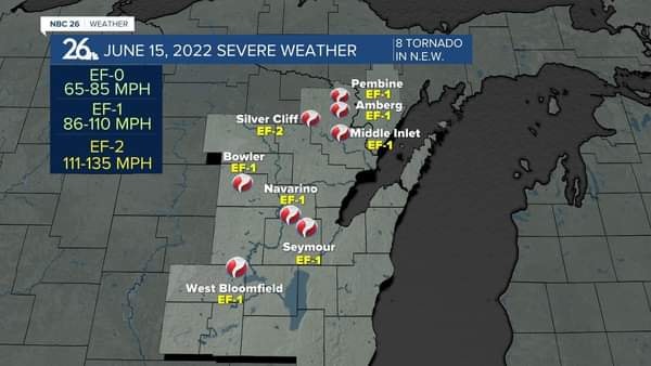
The storm damage remains a hot topic in the area. The NWS has identified three additional tornadoes that hit Marinette Co on the 15th, now including Pembine, Amberg, and Middle Inlet.

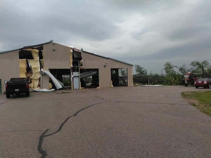
The tornadoes seem to be getting all of the fame here. What is being missed is that there were also dozens (if not hundreds) of areas that got leveled by straight line winds. They don’t get the fame but the damage is widespread and very real to the people affected. People riding ATV trails will see some of those areas as well as long stretches of trail blocked or closed.

There has been a fundraiser set up for the Silver Cliff VFD that got totaled in the tornado. That is wonderful. At the same time there are a lot of regular folks that could use some help too. A good example of this is the Lexow family, who’s house and business was right next door to the Silver Cliff  Fire & Rescue building. Their home and shop suffered extensive damage, along with 40 acres of woods. Some damage was insured, much of it wasn’t. The Lexows have been in Silver Cliff as long as I have and they have been active in the town’s fire and rescue departments and other town activities. They are good people and they could use some help. They have a fundraiser set up at https://www.gofundme.com/f/the-lexow-family.

Special thanks goes out to the hundreds of volunteers that came with saws and trucks and heavy equipment and crews to clean up the damage around the town roads, park, recycling center, and municipal buildings. Some people donated food, water, gas, money and labor. I am very thankful for those that stepped up and very proud of my town right now.

Earlier this week we were again in the 90s with high humidity. I think that we hit at least 96 or 97 both days. I asked the Mrs if she know why we had tornadoes the week before when it was in the 90s and not this week. The answer was that the warm air went all of the way up into the atmosphere this week. Last week there was cold air overrunning the hot moist air. That warm air wanted to be on top and the cold air wanted to be on the bottom and they violently changed places.

I hated physics in college but the physics behind what we saw on 6-15 is mind boggling. An extremely oversimplified example is that a 3’x3’x3′ cube of air can have over 2,212 foot pounds of lift at a CAPE 3000. A little over 2 pounds of air has over a ton of force lifting it up. As all of that air rises violently the cold air on top of the storm pours off of the sides of the storm and rushes to the ground at 100+mph and causes straight line winds. (Again really oversimplified) The forces involved are just mind boggling.

There is a chance of rain from Friday night through Saturday night with the best chance coming Saturday afternoon and evening. Sunday looks nice. As reliable as the weather forecast has been lately, there is an 80% chance of that changing.

I am going to be a busy boy next week so I am going to put 4th of July events out ahead of time.

Crooked Lake Sportsman’s Club Annual Picnic
Date: July 2, 2022
Time: 11:00 am – 7:00 pm
Link

Mountain Fire Department Independence Day Celebration
Date: July 2, 2022
Link

Townsend Annual 4th of July Celebration & Fireworks
Date: July 4, 2022
Link

Gillett 4th of July Celebration
Date: July 3, 2022 – July 4, 2022
Link

Crivitz

Wausaukee

This Weekend

That is it from here. Have a good weekend and thank you for visiting!

RJB


6-16-22 Storm Follow Up

Greetings and welcome!

The storm was a really bad one for the Town of Silver Cliff. The news came out late afternoon that the NWS has confirmed that it was indeed a tornado that hit the area of the Silver Cliff Fire & Rescue building.

The most serious damage was from about Lexow’s and east to Hwy I (Parkway north). Van Ark’s got hit bad, as did the fire dept building, the house next door, and all of the town buildings. The new town shop was leveled and the stuff inside damaged, and the roof is missing from the salt shed. The tornado continued north along Hwy I and took out a bunch of trees and hit several houses in the area. The news report said that it was 3-5 million in damages.

https://www.wbay.com/2022/06/17/silver-cliff-damage-estimated-3-million-5-million/

In typical Silver Cliff fashion people turned out in force to help clear debris. That work will continue for a while.

The Sheriff’s Dept asked that people not on work crews avoid the area. There were plenty of videos on FaceBook where people rode through the damage area. I listed a couple below.

There was another damage path a couple of miles east of the tornado along Fox Lake Rd. Several residents were trapped at home by an estimated 100 trees fallen across their road. They put the word out of FaceBook and people showed up to help in short order. I also heard about a damage path near Firelane Rd, and another near Tower Rd, but that is unconfirmed.

There was more storm damage in Athelstane, Crivitz, Wausaukee, and Middle Inlet. According to reports areas west of the Peshtigo River and south of Caldron Falls escaped major damage, but may see the occasional tree down..

The damage from the storm was very sporadic. A lot of areas scattered around saw significant damage, while many nearby areas did not. It is hard to pin down.

Right now your best resource for damage reports will be your neighbors. There were a lot of people putting damage reports on the FaceBook groups Crivitz Area Talk and on Silver Cliff Links of Interest.

I was at the GF’s house near Fisher’s Camp when the storm hit. It was bad enough that I got her and the dog out into our shelter (a very well built Quonset hut). It was a bad storm here, but the real bad stuff was 3.5 miles away by the Silver Cliff VFD.

She asked if this was the first tornado that I knew of in Silver Cliff. It was not. After hitting Riverview the Bear Paw/Riverview tornado made its way this way. It split in a Y shape and one branch of it went and hit the Thunder Mountain Ranch. There was devastation with huge trees taken out down by Caldron Falls and Ranch Road.

The northern branch of that jumped Crandall Lake 1/4 mile behind my house, and came down and took a bunch of tree tops at Rapids Resort and along the river. I know, I was there watching it.

Prior to its arrival I was outside at my house getting ready for it. I moved the cars to opposite ends of the property in hopes that at least one would be spared. I then got the generator set up and into the car. I could hear the approaching roar and could hear the carnage as the tornado took down steel sided buildings. If I ever hear that sound again it will be too soon.

At the last minute I got the GF into the car and evacuated to Rapids Resort where they have a basement. That is where I watched it come and hit a bunch of trees by the river before dissipating. At best it was an EF-0. By then it was pretty played out.

This was not the first tornado in Silver Cliff, but it was by far the worst.

If you want to pitch in go over to the FB Silver Cliff Links Of Interest group and see who needs help. You can also go to the Town Hall and sign up. There is plenty of cleanup to do and someone can use your talents.

It was a bad day in Silver Cliff and one that we won’t soon forget. We also need to remember how our community stepped up and showed up with chainsaws and heavy equipment to clear the damage and help people. We should be very proud of that.

RJB

Here are some links to videos that people took..

https://www.facebook.com/groups/1420166518312397/user/40601837/

The NWS page listing it as a confirmed tornado- https://www.weather.gov/grb/061522_severe_event

They have not updated with the EF rating or damage path details but they will when they catch up.

Wednesday 6-15-2022 Severe Weather Hit The Area!! Updated 10:20pm

10Pm

I got really lucky. Others didn’t.

The area around the Silver Cliff fire department, Van Ark’s, and the town park got hit hard. From what I hear it got wild from about Rustic Inn over to Jungle Jim’s. Reliable reports say that it’s really bad. Was it a tornado (probably) or straight line winds? They will know tomorrow when they can survey the debris path.

Here is a picture of the VFD from Facebook. Note all of the big trees from the park next door missing. One source said that the town shed got hit hard too.

Going north on Parkway from Fisher’s Camp there were several trees down across the road that were quickly cleared. The WI Fish & Hunt Club has a tree down on their roof. South of Fisher’s Camp on Parkway there was very little damage as far south as Ranch Rd.

Other reports include many trees down on Hwy X east of Popps, a probable tornado near Middle Inlet, and damage in Athelstane, Crivitz and Wausaukee. Reports from western Silver Cliff said that they did OK.

There were trees down here and there including one on Ranch Rd and one by Dockside.

Early reports are rarely reliable. This is the best info that I have now. Check out the group Crivitz Area Talk on Facebook for more reports.

RJB


Update 7:30pm-

At the GF’s house near Thornton’s and Fisher’s Camp we had a rowdy little storm with constant thunder, heavy rain, and some strong wind gusts. I cruised the block afterward and there were only a couple of small maple branches down.

Radar showed a stronger cell going just north of Hwy C. I am not sure how they fared.

At one point there was a radar indicated a tornado that went from by Antigo, over Lilly, and it moved east in Langlade and Oconto Counties. If it held together Lakewood and Townsend would have been in it’s path with us on the southern end of the warned area. Again I won’t know anything until some storm reports come in or I get eyes on.

The TV says that there was damage from about Waupaca and east and south of Shawano. They are showing straight line wind damage in Green Bay. Most of the warned areas were down that way.

Right now I am going to tell cabin owners to relax a little. I have a very limited view, but the storm was not damaging here at all. I will update when I know more.

RJB


Be ready for severe weather today and tonight!

As I type this at 5pm there is a major storm bearing down on most of eastern WI. The past day has been very hot (almost 90 now) with very high humidity. There is a cold front coming that will set off our hot juicy atmosphere like a stick of dynamite.

We are under a tornado watch right now. As I watch the line of storms approach I see quite a few areas being severe warned to our south and west. Unfortunately that part of the storm is heading this way.

The risk is that we could see high winds, big hail, quickly forming and large tornadoes, and straight line winds. There is also a risk of flash flooding with very high levels of moisture in the atmosphere, possibly coming as an inch or two of rain falling in a very short period of time.

This is a really dangerous atmosphere. We have CAPE values in the 2-3,000 J/kg range, and some areas downstate are in the 4,000 J/Kg range. With CAPE values over about 2,500 severe weather is pretty much as close to a sure thing as it gets. The Bear Paw/Riverview tornado and the super-destructive Drechero a few years ago came under similar conditions.

The big question is who is going to see the destructive or severe weather. It could be here, it could be the Fox Valley, it could be both. Make sure that you have your tornado and severe weather precautions and plans ready to go.

If you look at this graphic from the Severe Weather Prediction Center in Norman, OK you will see that most of the state is under a level 3 or level 4 risk of severe weather. The scale only goes to 5. At a 5 there are usually widespread tornado outbreaks.

I don’t want to be the little boy that cried wolf here. I rang the alarm bell last year under similar conditions and I’m happy that the severe weather went somewhere else. Prior to that I was right about the drechero and the Bear Paw tornado. Right now I am very concerned. My hope right now is that the storm will crap out as the sun input gets weaker later in the day.

Good luck!

RJB

Thursday 6-9-2022

Greetings and welcome!

It is a beautiful time of year in Wisconsin’s north woods. Everywhere that you look there is a different kind of plant flowering or having emerging leaves.

Recently I have been seeing a lot of deer fawns. The first one was about two weeks ago. It is cool seeing the spindly legged youngsters trying to keep up with Mom or playing and chasing each other. In addition to the fawns, the turtles are up out of the water and trying to lay eggs in the sand or gravel along roads and trails that are near wetlands.

I actually saw my first mosquito yesterday. That comes as a surprise. I expected that a month ago. More of interest the moths and butterflies are now very active. I have been seeing a lot of Viceroy butterflies (they almost look like a Monarch, but not quite). There have been quite a few sightings of the giants of the moth world, the Cecropia and Luna moths. There are many other moths too. Driving slowly after sunset will produce hundreds or maybe thousands in the headlights. Every year seems to be a stand out year for a certain species of bug. This year it is the Rosy Maple Moth.

There was some discussion on the local Facebook page about reduced activity at bird feeders. The consensus was that some had just stopped off for a visit and continued north in their migration. The other answer was that they are nesting and tending to their young. Still others speculated that natural food sources had started to produce. No one was really worried about it.

The rain has been reasonably steady recently and the grass is growing like crazy. The ditch line that I only cut once is now 9-10″ high.

The whitewater rafting and tubing continues to be good. I look for a minimum of 300CFS on the Peshtigo, and it is still a little above that. They have opened the Menominee River for rafting as well, and that will bring a fun ride.

I have one event on the calendar for this weekend… The Oconto County Breakfast On The Farm. Here is a link to information on that.

It looks like we have low fire danger for the weekend. It is low now and we are expecting a little rain possible for Friday and Saturday. Maybe I will finally catch a day where it isn’t too windy and I am not too busy to burn my brush.

That’s it from here. Have a good weekend and thank you for visiting!

RJB