Greetings and welcome!
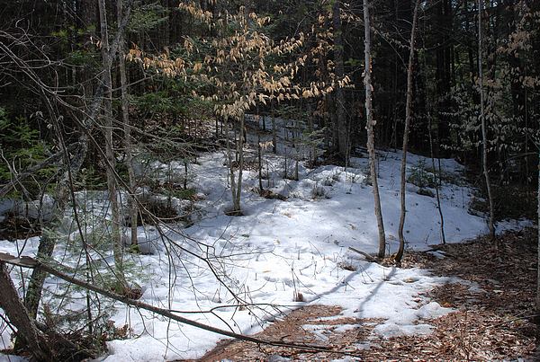
The weekend weather really brought around a lot of changes. The 70ish and mostly sunny weather knocked the winter down pretty good. There are still patches of snow in sheltered areas and in the woods, but a lot went away since last Thursday.
Someone asked if the ground is still frozen. Yes and no. In sunny spots the frost is mostly out and the ground is getting firmer.My driveway is pretty firm and the very first green grass is growing along the sunny part.
Places with mixed sun and shade are still sloppy with frost-out mud. I had spots that my foot sunk into the mud 3″ over the weekend. Shady spots can still hold 6-12″ of snow and still have frost in the ground.
That is what I see right here in Silver Cliff. I would expect that if you go north 10 miles or more they are not quite as far along with the spring thaw.
The big warm spell also did wonders for breaking down the ice on area lakes. Prior to late last week some lakes had 20+ inches of ice, and north of Hwy it was closer to 30 on some of them. The opening of fishing this coming weekend looked pretty grim. That changed somewhat.
When I went past Caldron Falls Flowage close to the river and past Boat Landing 11 it was open as far as the eye could see, probably at least down to Crane’s Bay. A friend said that the big end still holds a lot of ice. (Update- A FaceBook post from Fishers Camp shows an open bay.)
When I went past Chute Pond along 32 Monday evening the little bit that I could see from the road was about 40% open, mostly along the shoreline.
Maiden Lake looked like it was pretty well iced over, though the ice looked rotten from the sun.
 An over the bar report had High Falls mostly clear of ice except out by the islands. The Boat Landing right by Hwy X looked open when I went past Monday afternoon, but the parking lot looked soft.
So.. it looks like there are lakes to fish without the ice auger, but some will need to melt more before you could fish them. It is going to vary by the lake and depend on the weather this week.
That kind of goes hand in hand with the opening of the ATV trails. They have to wait until the ground firms up from the spring frost out mud before opening the trails back up. As I mentioned, I was sinking 3″ into the mud last weekend in some spots. I also walked across places that had 2″ of ice and 6-12″ of snow. ATV trails sometimes open the first weekend in May, but they won’t this year.
Oconto County is posting a May 10th opening date, Marinette and Forest Co are closed until further notice.
The warm weather melted a lot of the snow and put a lot of water into the rivers in a hurry. The Peshtigo River is really cranking, running about +30″ right now, and at 1,800cfs. That is huge. I consider anything above 300cfs the fun zone, and 800cfs really fun. Running 1,800 is monstrous.
If you want to see really big water whitewater, call Kosir’s today. This week rafting will be outrageous, and it won’t fall much by the weekend.
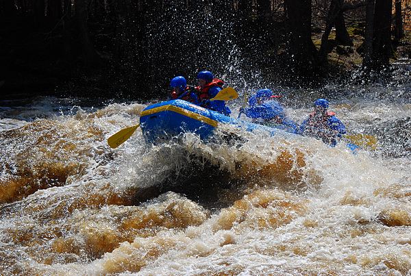
I am going to go out on a limb here and say that rafting will probably be above average right through Memorial Day. There is still a lot of winter to melt off, and the watershed is very well charged with water.
The warm weather has brought the first frogs to the little pond out back. Both the croakers and spring peepers are quite vocal right now, and it is really loud. It is pretty late in the month for first frogs, but they finally are here. The pond’s water is at near record high levels too.
This week brings an interesting weather forecast. The scenario has a stormy boundary between colder and warm air setting up right over the state and camping there through the weekend. That is expected to bring unsettled weather and a chance of rain daily up until about Sunday.
There are a lot of question marks involved here. Right now it looks like the boundary is set up about 150 miles to our west. If it stays there, we will stay on the warmer side and miss most of the precip. Right now it looks like central MN and far NW WI could see some significant snow out of it.
The GFS forecast model is showing it eventually inching this way and having more of a effect on us late week before sputtering out over the weekend.
I have seen similar scenarios before and it is a fairly low confidence forecast. It could end up as shown, but I wouldn’t bet my last Oreo on it. I would go ahead and plan for a good weekend with an outside chance of rain, at least until it gets closer and proves me wrong.
Beyond the weekend the GFS is showing much warmer and rather active weather for the next few weeks.
That is the news for today. Have a good week and thank you for visiting!
RJB