Storms were NOT severe here
6:30am-
Greetings and welcome!
A line of severe thunderstorms blazed through northeast WI last night. They brought hurricane force winds of up to 85 mph, and several suspected tornadoes closer to Green Bay, in the Fox Valley, and east toward the lake shore. Something like 50,000 people are out of power. They are still assessing the damage now that the sun is rising.
When the storms went through my neighborhood here in Silver Cliff they were NOT severe. There was a little lightning and I fell asleep to the rain pounding on the roof, but there were no high winds. I have a couple of trees with a lot of dead branches, and they did not drop a single one.
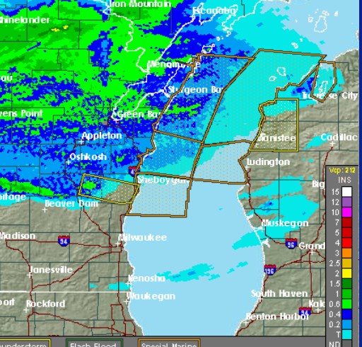
The local rain gauges at the USGS station by Kosir’s and at Athelstane weather are only showing a couple of tenths of an inch of rain. It seemed like a lot more than that. It was pounding on the roof for quite a while. Radar returns indicate 1/2″ of rain in the area, and that was before I fell asleep to the rain on the roof.
The southern 2/3 of Forest Co saw 1/2-2″, with most seeing at least an inch according to radar returns. That would be the Peshtigo River watershed, so it could bump water levels up for the weekend.
Anyway people with property in the area will be happy to hear that the weather was not severe here. I wanted to get that out ASAP. There were a couple of reports of wind damage near Marinette and in far southern Marinette Co down by Hwy 22. I will look into those as info becomes available.
RJB
Radar estimates of rainfall as of about 11 or 11:30 last night.
Ray,
Not such good news at our cabin near Kelly Lake. We had numerous trees down and power outages. The straight line winds did a number for sure!