Greetings and welcome!
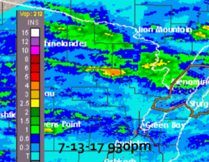
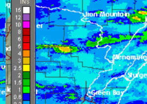
The rains came again last night. Like the Tuesday night rain the waves of the storm lined up on a rail and hit the same spots with wave after wave of thunderstorms and downpours. The bad news is that it hit the exact same spots as the Tuesday night storms. There are areas between here and Lakewood that got 3″ or more of rain two nights in a row.
I have a friend on the other side of Thunder Mountain that was on the east end of it. His driveway and yard are seriously wrecked from all of the runoff erosion. My driveway took it hard Tuesday night, but I haven’t seen the damage from last night yet.
The storm last night also caused a few power outages, including here. It went out about sunset, and came back on about midnight.
I know you guys saw the radar returns from Tuesday evening, now I am going to put Tue & Wed side by side to show how the same areas got hit. If you look right under the top stair step of Marinette Co you can see last night’s rain was 3+ inches and so was Tuesday night’s. Ouch.
The USGS river gauge by Kosir’s measured about 2.5″ of rainfall for the week, with all but 1/2″ coming in the past two days. I am going to say that it is understated a little. I would bet that private rain gauges show double that.
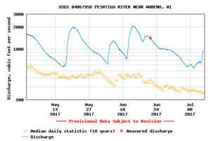
The river itself was not very affected by the Tuesday night rain, that was all south of the area that matters to the river. Last night’s rain also blessed the upper and lower watersheds. The river shot up from about 700CFS to 950 in under 12 hours, a rise of about 6″. That is a pretty fast spike, bearing witness to the intensity of the rainfall.
Whitewater rafting will again be outstanding this weekend. Right now the river is at about a +14″ by my guess. That is just incredible. Normally we would be at about a zero or maybe -2″. As far as CFS the median flow for today is 247cfs, right now it is at 940cfs. Incredible.
I ran a graph on the USGS gauge from May 1st to today. The river has not gone low enough to hit its mean flow since May 1st, but it did go above flood stage twice. By my reading of the graph, its lowest flow was about a +5″. That is something that I have never seen in my 25+ years of paying attention to it. Unbelievable. The mean flow is the little yellow triangles, the actual flow is in blue.
One previously discussed item is the float trips with Bear Point Yacht Club on the Menominee River. I mentioned it in an update a while ago, and I want to remind you that they run them every Saturday in July.
The weekend weather looks about as nice as it gets. Behind our rain are a couple of big areas of Canadian high pressure. Usually high pressure means nice days. In this case it will, but.. between the two areas of high pressure there will be a minor chance of a shower or storm. Right now the timing on this looks like it will be about sunset Saturday, but the NWS has a 30% chance after 1pm Saturday. The TV just said that there is a slight risk for severe weather for Saturday/Saturday night.
Well I have a million things to do so I am going to run along. Have a good weekend and thank you for visiting!
RJB


