Monday 7-22-19 More storm damage info

Greetings and welcome!

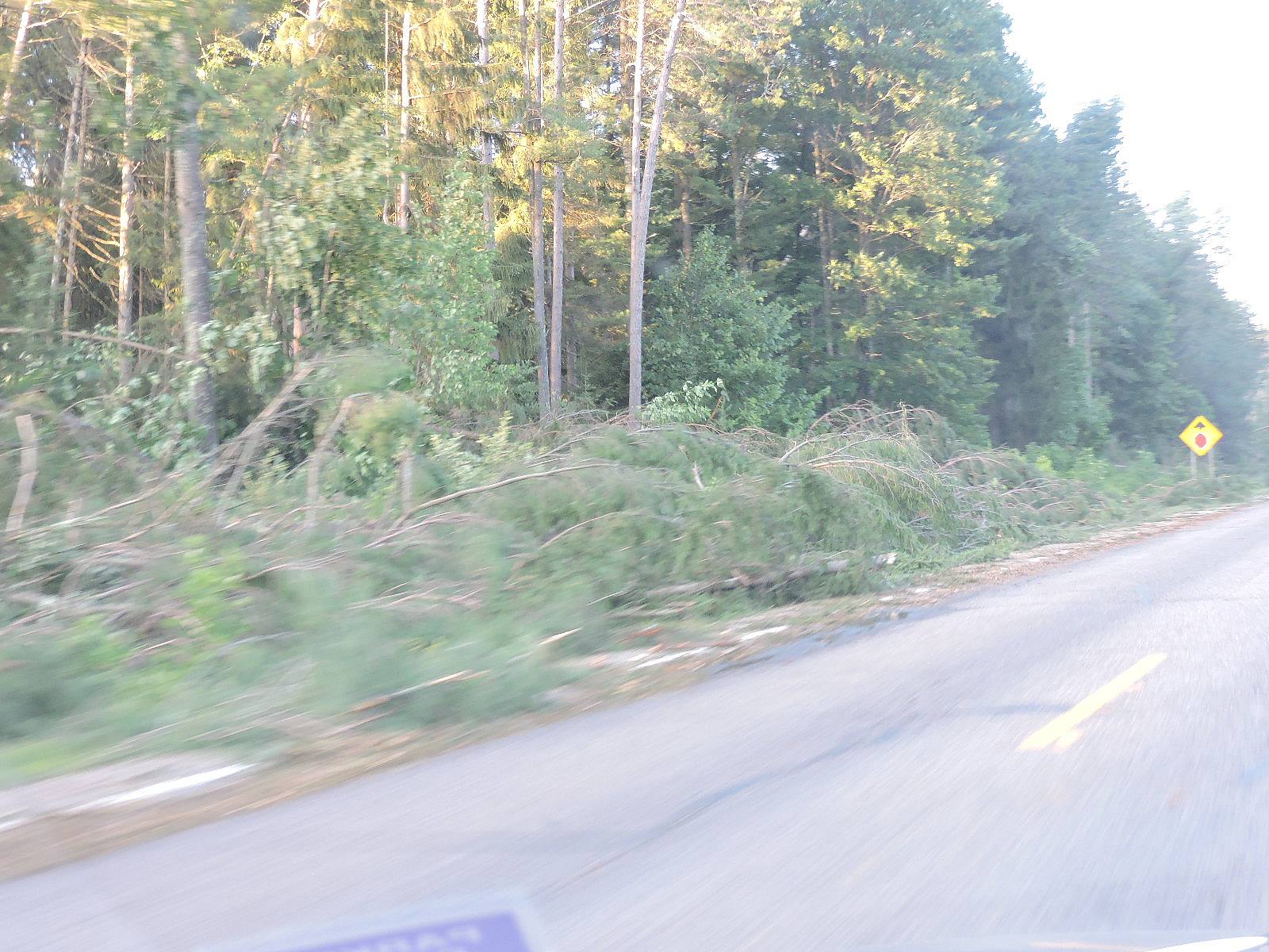
Yesterday someone showed me video of some of the storm damage. The debris was scattered in all directions indicating that the damage was probably caused by a tornado. What they did not know was where the footage was from (FaceBook). My guess is that it was from one of the areas west of Lake Winnebago that did have confirmed tornadoes.

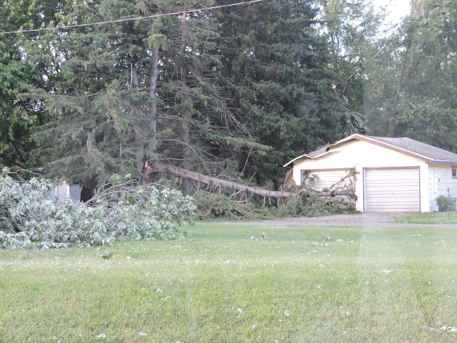
According to the news that was just on the NWS did a damage assessment and said that the damage in Oconto and Langlade Counties was NOT a tornado. They said that it was a macroburst.

A macroburst happens when the cold air on the top of the storm pours to the ground violently, hits the ground and spreads out ahead of the storm with straight line winds. We talked about how violently that the hot air was rising with a ton and a half of force lifting a 2.2 pound parcel of air. That violently rising air isn’t going to go into some magical stretchy balloon, the cold air that it is displacing is going to fall violently too. That is what the experts say happened.

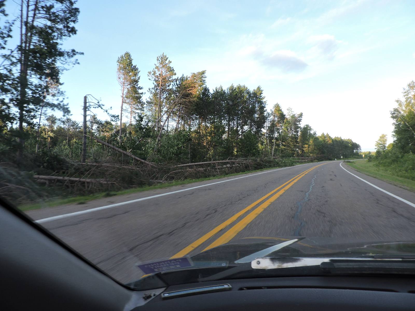
In order to be a macroburst instead of a MICROburst the area of downrushing winds has to be 2.5 miles wide or more. A macroburst can have winds over 130mph and last as long as 30 minutes, and have damage similar to an F3 tornado. The storm was moving at 60-70mph so it wasn’t going to last 30 minutes in one spot, but rather it would affect a large area as the storm moved E/SE. The TV weather guy mentioned 100mph winds.

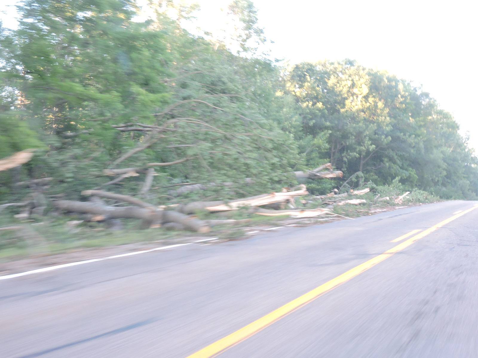
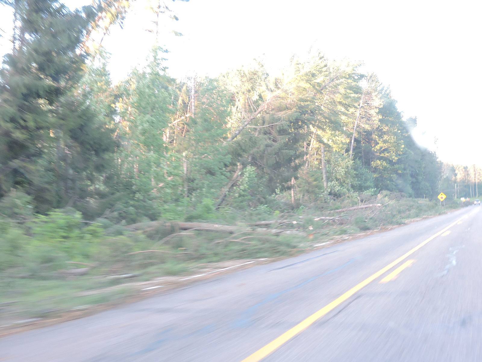
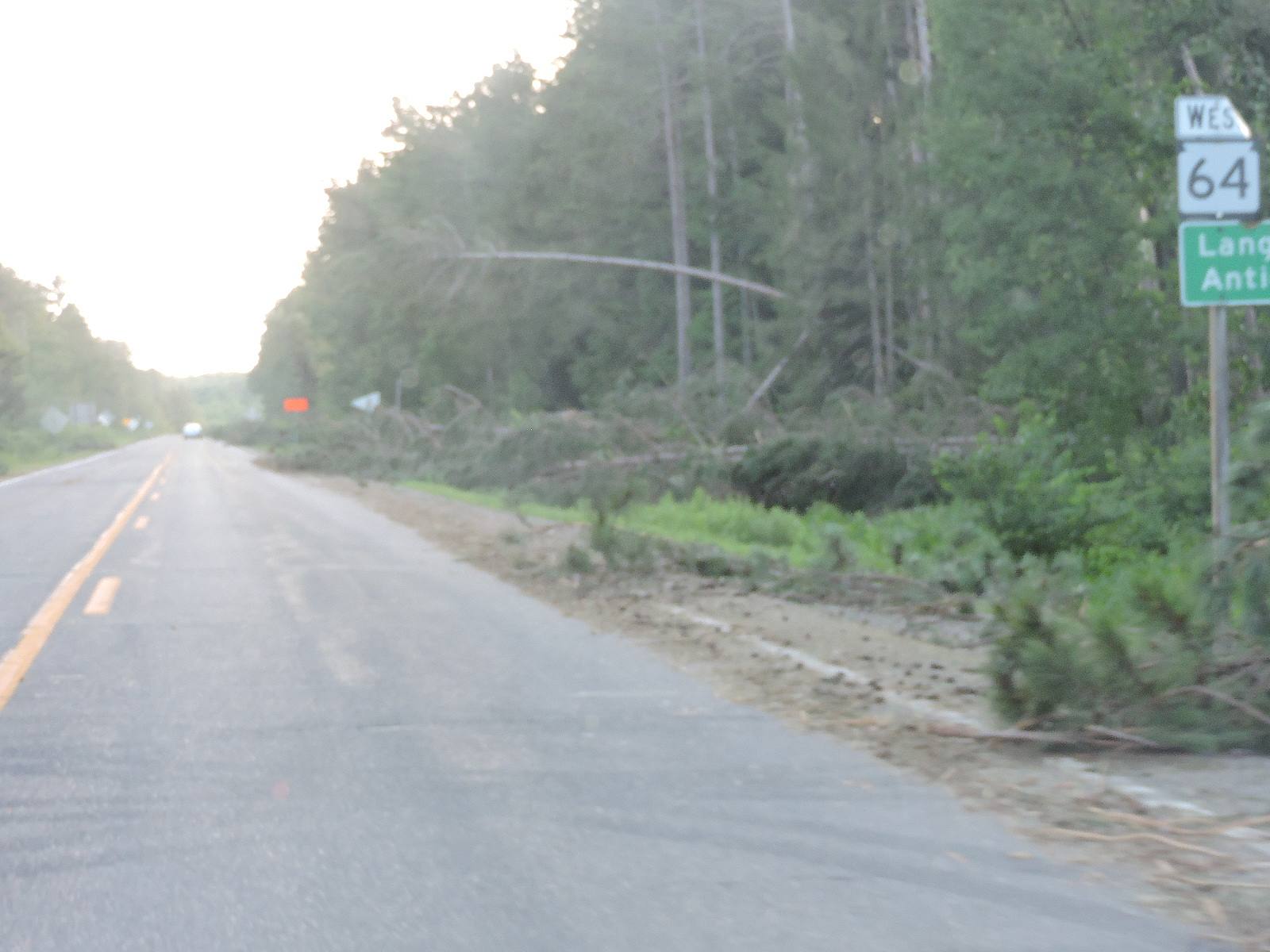
With the straight line nature of the damage that I saw, the widespread nature of it, and the extent of the damage, all of that is believable.

Whatever the case, areas from Antigo east to Hwy 32 and from Carter to Mountain and beyond really got clobbered. A lot of that was the same areas that got hit by the Bear Paw/Riverview tornado about 9 or 10 years ago. One person commented that a tornado would have been preferable, the damage path would be a lot less widespread.

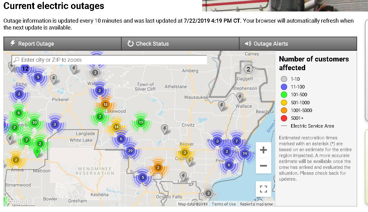
There are still a lot of power outages along the Hwy 32 corridor. I just got word that the Lakewood grocery store opened back up. The map shows a lot of people still without power. This is as of 4:19pm Monday afternoon. (Link)

As mentioned in my early morning update the Forest Service has shut down all of the ATV trails in the Nicolet National Forest, and they don’t want help cleaning it up. Storm damaged trees can have other trees laying on them or twisted up trunks and limbs and a lot of power stored up waiting for someone to release it with a chain saw. They don’t want untrained people in danger when that energy releases.

I have done storm cleanup before with a friend that owned a tree service. I have seen branches fly up hard enough to knock me over, saw still running, and I have seen huge trees spin like they were in a drill when one branch was cut. They aren’t being jerks, storm cleanup IS really really dangerous and they don’t want to see club members hurt.

At any rate I still think that we got very lucky with this storm. That is hard to swallow for a lot of people that took damage, and not fun to say. The setup in the atmosphere last Friday was tremendously dangerous and could have easily spawned an F4 or F5 tornado. The dynamics were very similar to those the day of the Joplin, MO tornado (Link) with a 4,000+CAPE and shear over 40k. That ended with a mile wide 250+mph EF5 tornado that killed 158 people and injured almost 1,200 more. The ground was scrubbed clean of anything less than a cement slab.

At any rate that is the latest update on the storm damage.

I am going to repeat this next bit in future posts because people need to know about it.

ATV riders are about to lose all of the roads and many of the ATV trails in Marinette County.

The word on the street is that they are considering a 30 day closure of all of the Marinette County roads to ATV/UTV traffic. The problem is people keep riding on roads that are signed no ATVs or not open to ATVs. There have been so many problems and complaints that the county is looking at closing their roads to the wheelers and future roads about to be approved have been stopped. They are considering a 30 day ‘punishment’ closure first. If the problems continue we are going to end up with a lot less ATV trails and road access.

But wait, it gets worse..

There are several towns reconsidering ATV access to town roads too. The problem there is people doing power stands and donuts on gravel town roads. Those roads are graded a couple of times a year, but the townies have to go and fix damage after every weekend or more often. They are not happy at all.

ATV riders need to self-police. When you see some jerk spinning cheerios on the gravel road or blazing past a no ATVs sign do something about it. That is the guy that is going to wreck it for everyone. We are right on the edge of losing a lot of trails. Once these roads and highways are gone it is going to be REALLY hard to get them open again.

It is really nice being able to ride right from the house and not have to trailer every time that you want to ride. Everyone wants to keep it that way including the towns and the county.

Have a good week and thank you for visiting!

RJB

Monday 7-22-19 Storm Damage closes ATV trails

Greetings and welcome!

From the Red Arrow Townsend snowmobile ATV Club-

Really Bad Storm Closes Area ATV Trails         

Sunday July 21, 2019

It’s 76° in beautiful downtown Townsend this afternoon. The trails are “CLOSED UNTIL FURTHER NOTICE” in the National Forest.We were notified by the Forest Service today that as a result of the terrible wind storm that went through the area Friday night, and all the trees down on the trails, they do not want anyone on the trails including Club work crews until further notice. They will be bringing in work crews employed by the USFS to do all trail restoration and will notify us when we will be allowed to enjoy our trails once again. There are some snarly bunches of trees tangled together that could be deadly for amateur chain saw operators, so this is a relief for our volunteers and their safety. I am sure they will try and get them reopened in a timely manner and insure everyone’s safety.

I will update this page as soon as I have further information to share with you.

FireCat

Saturday Night 7-20-19 Storm Damage Update

Greetings and welcome!

I did some travelling today and got an eye full of storm damage. Here is the Cliff’s Notes version..

Lakewood and Mountain are out of power and probably will be for a while. There was a lot of tree damage from Lakewood south to Mountain and west on 64, including trees on power lines. Both 32 and 64 west of 32 were definitely shut down last night with blown down trees across them. They got hit pretty hard down there and it will not be an easy cleanup. The highways are open, but there are still trees right on the road’s edge.

Route-

C&F in Silver Cliff to Lakewood on F, north to Carter on 32, south to Mountain BP gas station on 32, back to 64 west, west on 64 to Hwy T (Animal’s Bear Trail), 32 & F back to Silver Cliff.

Discussion-

This was supposed to be a grocery and cig run. The damage wasn’t to bad around here (none) so I didn’t expect what I found.

Hwy F to Prospect Lodge had only an occasional small branch down. Nothing to see here. At Prospect Lodge there was a tree down on a house and a pretty big one had fallen across the road and been removed enough to let traffic pass. There was an occasional tree down between there and the Lakewood golf course.

The golf course had a couple of trees and a sign down. A house across from the church & fire department just east of 32 on F had a bad night with trees down & a tarp on the roof. Power was out in Lakewood and all of the stores and gas stations were closed.

Going north to Townsend there was an occasional big tree down. Townsend had more big trees down, but they were scattered. The sumac bushes had leaves turned over like they had been thrashed pretty good. The power was on in Townsend.

There was an occasional tree down going north to Carter. The smoke shop was open but they had no fuel, I am guessing that they were on the casino’s generator power.

From Lakewood south things got really ugly. There were a lot of trees down between Lakewood and Mulligan’s, and again about a mile south. Some were on a power line. The ones south of Mulligan’s probably would have made the road impassable last night.

From Riverview VFD south to Mountain BP gas station they took it hard. There were a lot of trees down, and even a little wind damage to the gas station. Going west on 64 there were trees down across the road for at least the first half mile. Unless you were on a D-8 bulldozer that would have been impassible last night. There were a LOT of trees down. The damage was hit and miss from there west to Hwy T, but there was really a lot of it.

The power was out from Lakewood to Mountain. The Bear Trail was open but I didn’t know if they were using line power or a generator.

The bottom line is that there was damage from about Carter south to Mountain and points west. Lakewood and south they took it hard.

To me this looked like straight line wind damage. How do I know? The debris was all in the same direction. With a tornado the debris get scattered more randomly. Most of this damage was from the north with trees falling south or from the west and trees falling east. I didn’t have my drone so I couldn’t look at it from the air, but that is my assessment from the car.

That is little consolation to the guy who’s yard looks like a bomb went off, but straight line winds can be as strong as an EF0 or EF1 tornado. The EF0 starts at 65mph, and I would put a fat bet down that the areas that I saw today saw all of that. An EF1 starts at 86mph. I’d have to see radar forensics to really know how high that they gusted. The TV showed 65-70mph+ gusts last night.

Traffic was moderate and between that and the 7pm sun it was hard to get pictures. The camera apparently doesn’t do well at 55mph either. Whatever. Here are some pix.

RJB


Saturday 7-20-19

12 Noon

Greetings and welcome!

The morning news out of Green Bay did not cover our area much for storm damage. From what I saw on FaceBook-

-Hwy 32 north of 64 was blocked for a while.

-Mountain and Chute Pond had a lot of trees down and wind damage, power outages.

-Bear Paw scout camp had a ton of trees down

-Pelican Lake took a lot of wind damage

– A bluegrass festival NW of Antigo took a lot of damage.

-A friend near Parkway & W had a few big trees down.

-There were trees down reported to the NWS near Crivitz and a little SE of Wausaukee. I have not seen/heard reports from there yet.

We aren’t done!

Looking at the radar there are two big masses of red and orange heading this way.  Hopefully last night’s storms took enough energy out of the atmosphere that these won’t go severe. I guess not. There are tornado warnings between Green Bay and Oshkosh and points west. The severe area reaches north almost to Hwy 64.

There are two different lines of storms heading this way. One is almost on us, one is back by the MN/WI border. It looks like a wet and stormy Saturday, but so far it does not look like it will go severe north of Hwy 64. That could change so keep an eye on the sky and watch/listen for warnings.

In my opinion it seemed like the storms here faded out just a little too easily here last night, mostly because they came at sunset with less heating from the sun. (My apologies to our friends that did take damage). At that point the atmosphere did not fully purge, and there would be storms again today.

When we are at a 4,000 CAPE there is going to be a lot of energy and moisture for the atmosphere to purge. I saw where someone called yesterday a ‘particularly dangerous situation’. Yes indeed it was. I fully expected multiple tornadoes and possibly some really bad ones EF3 or bigger.

I will grossly oversimplify again here.

When I say that the CAPE is 4,000 j/kg, that means that a parcel of air on the ground has 4,000 joules of lift trying to make it rise. A typical Kg of air is about 27 cubic feet, and smaller when it is super humid and it weighs more. That would be a 3’x3’x3′ cube of air. At 4,000 j/kg there would be 2,950 foot-pounds of force trying to lift that 2.2 pound parcel of air. A ton and a half of force trying to lift 2..2 pounds of air? That is just an insane amount of force, and that air will rise violently. Now multiply that across a large area of northern WI and there is a really remarkable amount of energy involved. I don’t know how many “Hiroshima bombs” that would translate to, but it might be an apt way to quantify that amount of energy.

Unrelated-

I saw on Facebook where the county banned boats from the Twin Bridge Park beach for a month after someone kept stealing the swim area buoys. (Link)

Have a good Saturday and thank you for visiting!

RJB