Greetings and welcome!
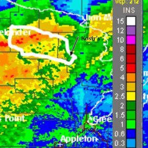
The big news this week was obviously the rain. We had strong storms and heavy rain, and it came wave after wave for three days. The USGS gauge by Kosir’s tallied 1.4″ since Monday, and almost an inch of it from yesterday. I find it a little hard to believe that Monday & Tuesday’s rain was only a little over 1/2″, or that yesterday’s hours of pounding rain was less than an inch. Right now I am more inclined to believe the radar returns with their 2-2.5″ estimate, and that could be low.
I can tell you that my pond is much bigger that it usually is, and much bigger than it was on Sunday. I also saw a FaceBook photo this morning of a friend’s dock on a nearby lake that was under water by quite a bit. Whatever the tally was we have seen a lot of rain.
My thoughts turned to the Peshtigo River and whitewater rafting. Here is a screen cap of the radar return based estimated rainfall. I cropped it, moved the scale to our area, and did a very rough approximation of the Peshtigo River watershed.
 My guess Tuesday morning was that the river would jump from about a +6′ to about a +16 or +17″ from Monday’s rain. We can flush that idea. In the past two days we have seen the river go from about 550cfs to almost 1500, and the slope of the graph indicates that it isn’t done coming up. Right now the morning gauge reading translates to about a +26″ level by my estimation.
(But wait.. if you order now..) Yes it gets better… The really heavy rain was way up in the far reaches of the watershed. With a fairly elongated watershed that rain takes 2-3 days to get to the whitewater stretch that we play in. Tuesday and Wednesday’s heavy rain hit hard way up by Crandon, Laona, and Armstrong Creek. That water should start reaching our stretch of river today and tomorrow.
Whitewater rafting this weekend will be epic.
I have watched this river for a couple of decades and I am usually pretty good at guessing weekend levels. This set up has me scratching my head. It takes a lot to raise the river farther once we get to about 24. The river channel widens and throws an extra dynamic into the equation. At the same time the radar returns are just estimates, and if 5-6″ is really 3″ that will throw me too. Anyway my wild guess for Saturday is that the Pesh will be in the 36 to 40″ range. Whatever the case, the water will be huge.
A couple of added bonuses- First of all we often don’t get water this high in spring when the snowmelt+runoff+frozen ground brings the big water. When it comes then, the water is usually in the 30-40 degree range. This weekend’s water will be much much warmer. Bonus #2 spring rafting pricing ended last weekend at Kosir’s and you can take a raft trip for $30 instead of $50. Bonus #3 is that you get to do it at above freezing temperatures. Bonus #4 there is so much water in the watershed that we are pretty much guaranteed fun water levels for Memorial Day weekend. I don’t see how it could possibly go below the fun zone in 9 days.
We really have a lot to look forward to in the whitewater department this weekend and beyond.
Not everyone will be happy about all of the rain. Contractors, loggers, excavators and other people that work outside had a tough week. There might be some driveway and trail erosion. I also saw some pretty attractive mud holes that used to be two lane ruts roads.
I am going to post what I have for the folks that check in at lunch hour and post the rest in about an hour.
Break
Today in the wake of the storm we have gusty winds and much cooler temperatures. Yesterday we were close to 80 and very humid. Today through Sunday we will be lucky to hit 60. Tonight we are expecting widespread frost and a low around 30. Friday night will be a little warmer at around 40.
Saturday they are predicting mid-50s for high temps and a low around 45 Saturday night. There is a 70% chance of rain Saturday, and 60% Saturday night.
There is a storm coming for Saturday that looks like it will affect us for about 12 hours with the main precip area. The GFS has it holding off into the afternoon, the NAM forecast model has it coming at about noon. The rainfall estimates are GFS=0.25-0.5″ NAM=0.25-0.5″, bordering 0.5-0.75″. Dice it or slice it, it doesn’t matter, Saturday looks wet. It would be great if the storm stalled and took a couple of extra days to get here, but that is only wishful thinking.
Sunday looks a lot better with only a chance of lingering showers and highs in the mid-50s.
Thinking about the ATV trails.. we won’t have to worry about dust this weekend.. and there might be some biiiig puddles and mud holes. Yeehaw!
I always like to exit on a happy note, so I am going to go. Have a good weekend and thank you for visiting!
RJB