Dude Where’s My Ark?
Greetings and welcome!
It has been an interesting week for weather, and it looks like the next week or so will be too.
We had a couple of nights this week that got down to 37 and 38 degrees in the early morning hours. That was thanks to a cool air mass over us and some clear skies allowing radiational cooling. The days with it were pretty nice, with upper 60s Monday, low 70s Tuesday and upper 70s yesterday.
Yesterday was one of those unique northern WI days that started out with a small fire in the wood burner to take the chill off in the morning, and a brief running of the AC in the afternoon to bring the house back under 80.
The weather ahead is the focus of my attention this morning. We have a warm, moist unstable air mass moving our way, and it will put a chance of rain into the forecast pretty much daily for the next week, along with some 80+ temperatures.
Some of the atmospheric dynamics shown for over the weekend are pretty impressive. There will be plenty of moisture for the storms to work with, and a highly unstable atmosphere. The NWS forecast discussion mentions precipitable moisture values at 150-200% of normal, and CAPE values in the 2,500-3,500 J/KG range.
The CAPE values have my attention. According to the Tornado Chaser’s site, 2500-3500 is a very unstable atmosphere and 3,500+ is extremely unstable. With an atmosphere that unstable we can expect a chance at torrential rains, strong winds, and big hail.
Usually when I see CAPE values over about 2,000 I start worrying about severe weather. My memory is a fickle servant, but I am thinking that the CAPEs were in the low 2,000 range when the Riverview tornado came through. I am not sure why we are not seeing discussion of severe storms when CAPEs are considerably higher than that. There is a good chance that it will come as the heavy weather gets closer.
Anyway, we are looking at a wet weekend.
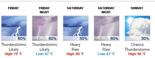
I am not expecting all day every day rain, but more like afternoon thunderstorms as the atmosphere gets whipped up by the sun, and the resulting storms lasting into the night.
In a scenario like this with a wet and very unstable atmosphere, it is almost impossible to say when or where it will rain. It could be one of those weekends where south of 64 they get pounded and we get away with a mostly dry weekend, or it could go the other way. All that I can say for sure is that somewhere in the upper Midwest is going to get a lot of rain and some big storms.
The moisture values in the wet atmosphere are pretty impressive. Right now the 5 day HPC QPF has us in the 2-2.5″ of rain range between 6am today and 6am Tuesday. The Hydrology section of the NWS forecast discussion is as follows..
.HYDROLOGY… ISSUED AT 418 AM CDT THU JUN 20 2013 SEVERAL COMPLEXES OF THUNDERSTORMS ARE EXPECTED FROM FRIDAY INTO EARLY NEXT WEEK. A VERY WARM AND HUMID AIR MASS WILL BECOME ENTRENCHED ACROSS THE REGION LATE THIS WEEK AND PERSIST INTO EARLY NEXT WEEK. PRECIPITABLE WATER VALUES BETWEEN 150 TO 200 PERCENT OF NORMAL ARE EXPECTED…LEADING TO THE LIKELIHOOD OF TORRENTIAL RAINS AND POTENTIAL FOR URBAN FLOODING DUE TO THE INTENSE RAINFALL RATES. ANY TRAINING OR SLOW MOVING THUNDERSTORMS WILL INCREASE THE RISK OF FLOODING. RAINFALL AMOUNTS OVER THE NEXT 5 DAYS SHOULD RANGE FROM 1 TO 3 INCHES WITH LOCALLY HIGHER AMOUNTS. WOULD NOT BE SURPRISED IF THERE WERE A FEW AMOUNTS CLOSE TO 5 INCHES IF STORMS MOVE OVER THE SAME REGION ON SEVERAL DAYS INTO EARLY NEXT WEEK. &&
So, it might be a wet weekend.
About the only event that I am seeing right now is a Saturday fundraiser at Randall’s Resort for the Mountain Ambulance Service. It runs from 10am-10pm with food, music and raffles, and is obviously for a good cause.
Unfortunately I don’t have a lot more on my outline to talk about today. It was another busy week with work. I can tell you that last night’s sunset was exceptional, but unfortunately I didn’t get to spend time watching it or take any pictures.
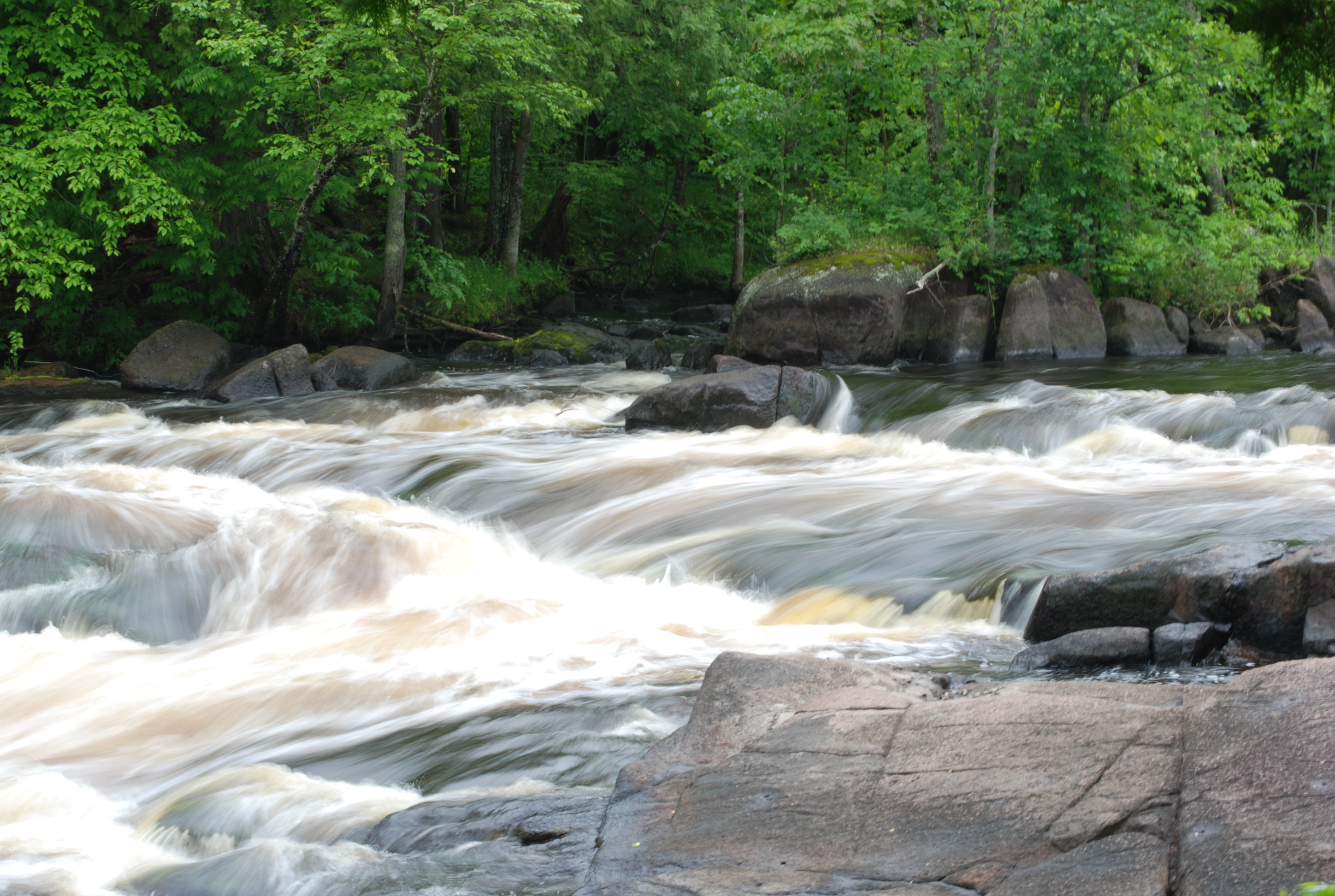
I did have a chance before one of the rafting trips last weekend to play with a little trick photography down by the river. It was cloudy at the time, and with a little manipulation of the camera settings I came away with a new desktop background. This is the image straight out of the camera, with no Photoshop or adjustment at all. I’ll share it in its full size, so you can have it too. Click it and when the big image loads, right click it and pick either save as.. or set as desktop background.
That is news from here. Have a good weekend and thank you for visiting!
RJB
We could really use an ATV/UTV/snowmobile/boat/ultralite all purpose vehicle here in Wisconsin…..!
Thanks Ray! Nice screen saver! I would have to put this one in my top 3 that you have provided in the last 10+ years I’ve been reading your site!
Please keep them coming!
Great shot! Thanks for the new desktop background.