10Pm
I got really lucky. Others didn’t.
The area around the Silver Cliff fire department, Van Ark’s, and the town park got hit hard. From what I hear it got wild from about Rustic Inn over to Jungle Jim’s. Reliable reports say that it’s really bad. Was it a tornado (probably) or straight line winds? They will know tomorrow when they can survey the debris path.
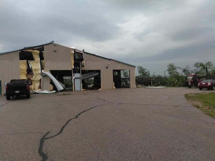
Here is a picture of the VFD from Facebook. Note all of the big trees from the park next door missing. One source said that the town shed got hit hard too.
Going north on Parkway from Fisher’s Camp there were several trees down across the road that were quickly cleared. The WI Fish & Hunt Club has a tree down on their roof. South of Fisher’s Camp on Parkway there was very little damage as far south as Ranch Rd.
Other reports include many trees down on Hwy X east of Popps, a probable tornado near Middle Inlet, and damage in Athelstane, Crivitz and Wausaukee. Reports from western Silver Cliff said that they did OK.
There were trees down here and there including one on Ranch Rd and one by Dockside.
Early reports are rarely reliable. This is the best info that I have now. Check out the group Crivitz Area Talk on Facebook for more reports.
RJB
Update 7:30pm-
At the GF’s house near Thornton’s and Fisher’s Camp we had a rowdy little storm with constant thunder, heavy rain, and some strong wind gusts. I cruised the block afterward and there were only a couple of small maple branches down.
Radar showed a stronger cell going just north of Hwy C. I am not sure how they fared.
At one point there was a radar indicated a tornado that went from by Antigo, over Lilly, and it moved east in Langlade and Oconto Counties. If it held together Lakewood and Townsend would have been in it’s path with us on the southern end of the warned area. Again I won’t know anything until some storm reports come in or I get eyes on.
The TV says that there was damage from about Waupaca and east and south of Shawano. They are showing straight line wind damage in Green Bay. Most of the warned areas were down that way.
Right now I am going to tell cabin owners to relax a little. I have a very limited view, but the storm was not damaging here at all. I will update when I know more.
RJB
Be ready for severe weather today and tonight!
As I type this at 5pm there is a major storm bearing down on most of eastern WI. The past day has been very hot (almost 90 now) with very high humidity. There is a cold front coming that will set off our hot juicy atmosphere like a stick of dynamite.
We are under a tornado watch right now. As I watch the line of storms approach I see quite a few areas being severe warned to our south and west. Unfortunately that part of the storm is heading this way.
The risk is that we could see high winds, big hail, quickly forming and large tornadoes, and straight line winds. There is also a risk of flash flooding with very high levels of moisture in the atmosphere, possibly coming as an inch or two of rain falling in a very short period of time.
This is a really dangerous atmosphere. We have CAPE values in the 2-3,000 J/kg range, and some areas downstate are in the 4,000 J/Kg range. With CAPE values over about 2,500 severe weather is pretty much as close to a sure thing as it gets. The Bear Paw/Riverview tornado and the super-destructive Drechero a few years ago came under similar conditions.
The big question is who is going to see the destructive or severe weather. It could be here, it could be the Fox Valley, it could be both. Make sure that you have your tornado and severe weather precautions and plans ready to go.
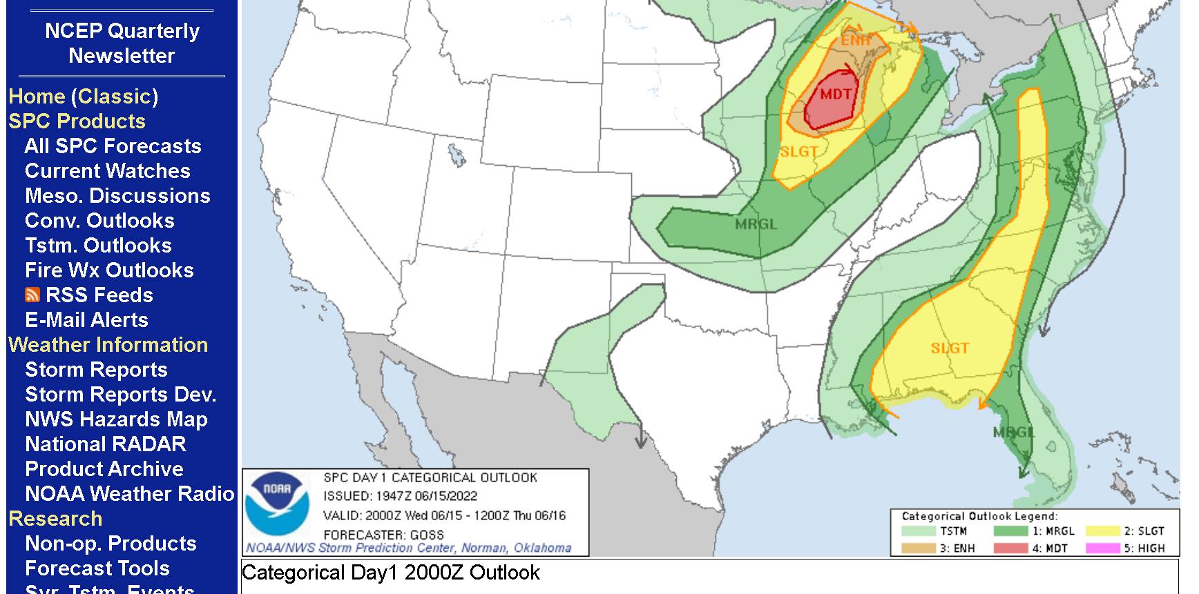
If you look at this graphic from the Severe Weather Prediction Center in Norman, OK you will see that most of the state is under a level 3 or level 4 risk of severe weather. The scale only goes to 5. At a 5 there are usually widespread tornado outbreaks.
I don’t want to be the little boy that cried wolf here. I rang the alarm bell last year under similar conditions and I’m happy that the severe weather went somewhere else. Prior to that I was right about the drechero and the Bear Paw tornado. Right now I am very concerned. My hope right now is that the storm will crap out as the sun input gets weaker later in the day.
Good luck!
RJB